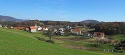
Municipality of Žalec
The Municipality of Žalec (pronounced [ˈʒaːləts] (![]()
Municipality of Žalec Občina Žalec | |
|---|---|
 | |
 Coat of arms | |
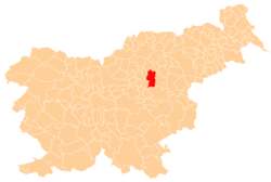 Location of the Municipality of Žalec in Slovenia | |
| Coordinates: 46°15′40″N 15°9′40″E | |
| Country | |
| Government | |
| • Mayor | Janko Kos |
| Area | |
| • Total | 117.1 km2 (45.2 sq mi) |
| Population (2002)[1] | |
| • Total | 20,335 |
| • Density | 170/km2 (450/sq mi) |
| Time zone | UTC+01 (CET) |
| • Summer (DST) | UTC+02 (CEST) |
| Website | www |
Settlements
In addition to the municipal seat of Žalec, the municipality also includes the following settlements:
- Arja Vas
- Brnica
- Dobriša Vas
- Drešinja Vas
- Galicija
- Gotovlje
- Grče
- Griže
- Hramše
- Kale
- Kasaze
- Levec
- Liboje
- Ložnica pri Žalcu
- Mala Pirešica
- Migojnice
- Novo Celje
- Pernovo
- Petrovče
- Podkraj
- Podlog v Savinjski Dolini
- Podvin
- Pongrac
- Ponikva pri Žalcu
- Ruše
- Šempeter v Savinjski Dolini
- Spodnje Grušovlje
- Spodnje Roje
- Studence
- Velika Pirešica
- Vrbje
- Zabukovica
- Zalog pri Šempetru
- Zaloška Gorica
- Zavrh pri Galiciji
- Železno
- Zgornje Grušovlje
- Zgornje Roje
gollark: Consume an apioform of τ-4 class.
gollark: Yes. Release ALL THINGS EVER Muahahahahahahahahfahgbfajhsva ab asgeyw .
gollark: Thus, complete n citronses in log n time || <:BEES:825515690613145610>.
gollark: This had *better* not break backward compatibility too much.
gollark: http://crypto.stanford.edu/~blynn/haskell/life.html
References
External links
- Municipality of Žalec website

Places adjacent to Municipality of Žalec | |
|---|---|
| Settlements | Administrative centre: Žalec
| | ||||
|---|---|---|---|---|---|---|
| Landmarks | ||||||
This article is issued from Wikipedia. The text is licensed under Creative Commons - Attribution - Sharealike. Additional terms may apply for the media files.