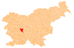
Municipality of Vrhnika
The Municipality of Vrhnika (pronounced [ˈʋəɾxnika] (![]()
Municipality of Vrhnika Občina Vrhnika | |
|---|---|
 | |
 Coat of arms | |
 Location of the Municipality of Vrhnika in Slovenia | |
| Coordinates: 45°58′N 14°18′E | |
| Country | |
| Government | |
| • Mayor | Daniel Cukjati |
| Area | |
| • Total | 116 km2 (45 sq mi) |
| Population (2012)[1] | |
| • Total | 16,477 |
| • Density | 140/km2 (370/sq mi) |
| Time zone | UTC+01 (CET) |
| • Summer (DST) | UTC+02 (CEST) |
| Website | www |
Settlements
In addition to the municipal seat of Vrhnika, the municipality also includes the following settlements:
gollark: Though at least *it* has generics!
gollark: Same problem as Go, except instead of simplicity they went for overcomplicated crazy syntactical whatsits.
gollark: No.
gollark: Well, you might write less code if you're busy staring at blurry text.
gollark: Let us all configure our IDEs to blur text annoyingly.
References
External links

- Municipality of Vrhnika website (in Slovene)
- Municipality of Vrhnika on Geopedia
This article is issued from Wikipedia. The text is licensed under Creative Commons - Attribution - Sharealike. Additional terms may apply for the media files.