Podlog v Savinjski Dolini
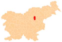
Podlog v Savinjski Dolini (pronounced [ˈpoːdlɔk ʍ saˈʋiːnski dɔˈliːni]; Slovene: Podlog v Savinjski dolini) is a settlement in the Savinja Valley in the Municipality of Žalec in east-central Slovenia. It lies northeast of Šempeter. The area is part of the traditional region of Styria. The municipality is now included in the Savinja Statistical Region.[2]
Podlog v Savinjski Dolini | |
|---|---|
 Podlog v Savinjski Dolini Location in Slovenia | |
| Coordinates: 46°15′51.03″N 15°8′0.1″E | |
| Country | |
| Traditional region | Styria |
| Statistical region | Savinja |
| Municipality | Žalec |
| Area | |
| • Total | 2.2 km2 (0.8 sq mi) |
| Elevation | 272 m (892 ft) |
| Population (2002) | |
| • Total | 288 |
| [1] | |
Name
The name of the settlement was changed from Podlog to Podlog v Savinjski Dolini in 1953.[3]
gollark: > youll get into contact with the same number of people at the store regardless of whos out doing something elseBut a different number of them will have COVID-19 and might be able to infect you.
gollark: I guess if you could hibernate somehow...
gollark: Sadly, humans just don't have the surface area.
gollark: And you are less likely to be infected there if you have fewer people going out for nonessential reasons.
gollark: It's not a risk you can choose.
References
- Statistical Office of the Republic of Slovenia
- Žalec municipal site
- Spremembe naselij 1948–95. 1996. Database. Ljubljana: Geografski inštitut ZRC SAZU, DZS.
External links
This article is issued from Wikipedia. The text is licensed under Creative Commons - Attribution - Sharealike. Additional terms may apply for the media files.
