Municipality of Kostanjevica na Krki
The Municipality of Kostanjevica na Krki (pronounced [kɔˈstaːnjɛʋitsa na ˈkəɾki] (![]()
Municipality of Kostanjevica na Krki Občina Kostanjevica na Krki | |
|---|---|
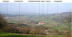 View of the Municipality of Kostanjevica na Krki from the village of Male Vodenice | |
 Coat of arms | |
 Location of the Municipality of Kostanjevica na Krki in Slovenia | |
| Coordinates: 45°51′N 15°25′E | |
| Country | |
| Elevation | 150.4 m (493.4 ft) |
| Population (2002)[1] | |
| • Total | 751 |
| Time zone | UTC+01 (CET) |
| • Summer (DST) | UTC+02 (CEST) |
| Postal code | 8311 |
| Website | www |
| Source: Statistical Office of the Republic of Slovenia, census of 2002. | |
Settlements
In addition to the municipal seat of Kostanjevica na Krki, the municipality also includes the following settlements:
gollark: Then you'll just have to do actual engineering (#3) or waiting ages (#1).
gollark: Essentially.
gollark: If you want to mine addresses too you can probably either:- wait several years until people stop caring about krist and get them to give you the algorithm- infiltrate tmpim somehow and obtain the code- ... learn... advanced mathematics/CS stuff of some kind?
gollark: it doesn't say that, no.
gollark: I'm immortal according to the potatOS privacy policy, thus no.
References
External links

- Kostanjevica municipal website (in Slovene)
- Municipality of Kostanjevica na Krki on Geopedia
Places adjacent to Municipality of Kostanjevica na Krki | ||||||||||
|---|---|---|---|---|---|---|---|---|---|---|
| ||||||||||
| Settlements | Administrative centre: Kostanjevica na Krki
| | ||||
|---|---|---|---|---|---|---|
| Landmarks |
| |||||
This article is issued from Wikipedia. The text is licensed under Creative Commons - Attribution - Sharealike. Additional terms may apply for the media files.