Mulgrave-et-Derry, Quebec
Mulgrave-et-Derry, is a village north of Mayo, in the Papineau Regional County Municipality, Quebec, Canada. The region includes a number of notable lakes, including Gull Lake, Hawk Lake, Lady Lake, Smallian Lake, Lac St. Sixte, Lac La Blanche and Little Lake. Community buildings include the Hill and Gully Riders Snowmobile Club, St. Matthew's Evangelical Lutheran Church, and Our Lady of Light Roman Catholic Church ( now Our Lady of Light Cultural Centre).
Mulgrave-et-Derry | |
|---|---|
Municipality | |
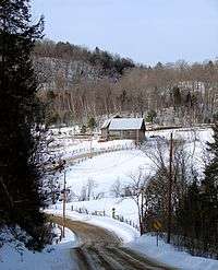 Quebec Route 315 through Blanche, Mulgrave-et-Derry | |
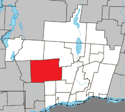 Location within Papineau RCM | |
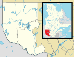 Mulgrave-et-Derry Location in western Quebec | |
| Coordinates: 45°47′N 75°22′W[1] | |
| Country | Canada |
| Province | Quebec |
| Region | Outaouais |
| RCM | Papineau |
| Constituted | January 1, 1870 |
| Government | |
| • Mayor | Michael Kane |
| • Federal riding | Argenteuil—Papineau—Mirabel |
| • Prov. riding | Papineau |
| Area | |
| • Total | 319.00 km2 (123.17 sq mi) |
| • Land | 293.75 km2 (113.42 sq mi) |
| Population (2016)[3] | |
| • Total | 369 |
| • Density | 1.3/km2 (3/sq mi) |
| • Pop 2011-2016 | |
| • Dwellings | 396 |
| Time zone | UTC−5 (EST) |
| • Summer (DST) | UTC−4 (EDT) |
| Postal code(s) | J8L 2H2 |
| Area code(s) | 819 |
| Highways | |
| Website | www |
The Wallingford-Back mine, once one of Canada's largest sources of quartz, is located in Mulgrave-et-Derry. It became a tourist destination after ceasing operations in the 1970s, but also became unsafe; in 2017, it was barricaded.[4]
Demographics
| Canada census – Mulgrave-et-Derry, Quebec community profile | |||
|---|---|---|---|
| 2016 | 2011 | ||
| Population: | 369 (0.8% from 2011) | 366 (% from 2006) | |
| Land area: | 293.75 km2 (113.42 sq mi) | 295.99 km2 (114.28 sq mi) | |
| Population density: | 1.3/km2 (3.4/sq mi) | 1.2/km2 (3.1/sq mi) | |
| Median age: | 55.8 (M: 55.8, F: 55.6) | 52.3 (M: 52.8, F: 51.8) | |
| Total private dwellings: | 396 | 428 | |
| Median household income: | $57,728 | ||
| References: 2016[5] 2011[6] earlier[7] | |||
| Year | Pop. | ±% |
|---|---|---|
| 1986 | 225 | — |
| 1991 | 233 | +3.6% |
| 1996 | 250 | +7.3% |
| 2001 | 235 | −6.0% |
| 2006 | 389 | +65.5% |
| 2011 | 366 | −5.9% |
| 2016 | 369 | +0.8% |
| The 2011 population is based on the revised count. Source: Statistics Canada | ||
gollark: EPUB can do that?
gollark: EPUB can do images too?
gollark: "What's that, you want to look at something on a screen with a different aspect ratio to the document? HAHAHAHAHAHAHAHA enjoy scrolling, bee"
gollark: I agree.
gollark: It's not the best-designed format but at least it's reflowable.
References
- Reference number 379132 of the Commission de toponymie du Québec (in French)
- Geographic code 80085 in the official Répertoire des municipalités (in French)
- "(Code 2480085) Census Profile". 2016 census. Statistics Canada. 2017.
- "Barricades installed to keep tourists away from scenic Outaouais mine". CBC News. 30 July 2017. Retrieved 30 July 2017.
- "2016 Community Profiles". 2016 Canadian Census. Statistics Canada. February 21, 2017. Retrieved 2020-01-30.
- "2011 Community Profiles". 2011 Canadian Census. Statistics Canada. July 5, 2013. Retrieved 2020-01-30.
- "2001 Community Profiles". 2001 Canadian Census. Statistics Canada. February 17, 2012.
External links

- http://ca.epodunk.com/profiles/quebec/mulgrave-et-derry/2001563.html
- http://www.bytown.net/mayoquebec.htm
Places adjacent to Mulgrave-et-Derry, Quebec | ||||||||||
|---|---|---|---|---|---|---|---|---|---|---|
| ||||||||||
| Cities | |
|---|---|
| Municipalities | |
| Townships | |
| |
This article is issued from Wikipedia. The text is licensed under Creative Commons - Attribution - Sharealike. Additional terms may apply for the media files.