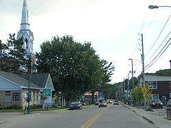
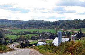
Chénéville, Quebec
Chénéville is a town and municipality in the Outaouais region of Quebec, Canada, part of the Papineau Regional County Municipality.
Chénéville | |
|---|---|
Municipality | |
 | |
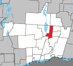 Location within Papineau RCM | |
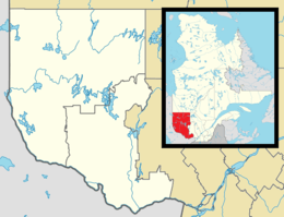 Chénéville Location in western Quebec | |
| Coordinates: 45°53′N 75°03′W[1] | |
| Country | Canada |
| Province | Quebec |
| Region | Outaouais |
| RCM | Papineau |
| Settled | 1850s |
| Constituted | August 21, 1996 |
| Government | |
| • Mayor | Gilles Tremblay |
| • Federal riding | Argenteuil—Papineau—Mirabel |
| • Prov. riding | Papineau |
| Area | |
| • Total | 66.80 km2 (25.79 sq mi) |
| • Land | 66.76 km2 (25.78 sq mi) |
| Population (2016)[3] | |
| • Total | 764 |
| • Density | 11.4/km2 (30/sq mi) |
| • Pop 2011-2016 | |
| • Dwellings | 502 |
| Time zone | UTC−5 (EST) |
| • Summer (DST) | UTC−4 (EDT) |
| Postal code(s) | J0V 1E0 |
| Area code(s) | 819 |
| Highways | |
| Website | www |
History
First settled in the middle of the 19th century, its first post office opened in 1864 under the name Sévigné, perhaps in honour of the Marquise de Sévigné (1626-1696). From 1876 to 1884, the post office was known as Hartwell, and from 1884 on, it became Chénéville. It could be that it was renamed in memory of a nephew of Hercule Chéné who was born around 1864.[4] (Pierre Hercule Chéné (1834-1904) was mayor of Ripon-et-Hartwell, Hartwell-et-Suffolk, Hartwell, and Hartwell-et-Preston, and counsellor of Chénéville.[5])
In 1903, the village separated from the United Township Municipality of Hartwell-et-Preston to form the Village Municipality of Chénéville, following a request from 55 citizens submitted to the Lieutenant Governor.[4] Hygin Locas was its first mayor. At that time, the village consisted of 26 homes and 6 streets.[5]
The Vinoy Post Office opened in 1871, most likely named in honour of the French General Joseph Vinoy (1800-1880). In 1920, the western portion of Suffolk Township separated and formed the Township Municipality of Suffolk-West, but was renamed Vinoy three years later. On August 21, 1996, the Vinoy merged to Chénéville and they formed the new Municipality of Chénéville.[4]
Demographics
| Canada census – Chénéville, Quebec community profile | |||
|---|---|---|---|
| 2016 | 2011 | ||
| Population: | 764 (-3.5% from 2011) | 792 (1.0% from 2006) | |
| Land area: | 66.76 km2 (25.78 sq mi) | 65.15 km2 (25.15 sq mi) | |
| Population density: | 11.4/km2 (30/sq mi) | 12.2/km2 (32/sq mi) | |
| Median age: | 53.5 (M: 52.2, F: 55.5) | 51.3 (M: 50.9, F: 51.5) | |
| Total private dwellings: | 502 | 463 | |
| Median household income: | $39,040 | $41,793 | |
| References: 2016[6] 2011[7] earlier[8] | |||
| Year | Pop. | ±% |
|---|---|---|
| 1986 | 737 | — |
| 1991 | 760 | +3.1% |
| 1996 | 755 | −0.7% |
| 2001 | 738 | −2.3% |
| 2006 | 784 | +6.2% |
| 2011 | 792 | +1.0% |
| 2016 | 764 | −3.5% |
| Population amounts prior to 1998 are total of Chénéville VL and Vinoy SD. Source: Statistics Canada | ||
- Population total in 1996:
- Chénéville (village): 646
- Vinoy (municipality): 109
- Population in 1991:
- Chénéville (village): 635
- Vinoy (municipality): 125
Mother tongue:[3]
- English as first language: 3.3%
- French as first language: 94.1%
- English and French as first language: 0.7%
- Other as first language: 0.7%
Education
A portion of the village lies in the Sir Wilfrid Laurier School Board, which operates Anglophone public schools:
- Laurentian Regional High School in Lachute[9]
References
- Reference number 319411 of the Commission de toponymie du Québec (in French)
- "Ministère des Affaires municipales, des Régions et de l'Occupation du territoire". Retrieved 2012-03-11.
- "(Code 2480103) Census Profile". 2016 census. Statistics Canada. 2017.
- "Chénéville (Municipalité)" (in French). Commission de toponymie du Québec. Archived from the original on 2016-03-04. Retrieved 2009-01-08.
- "Patrimoine Municipalité de Chénéville" (in French). Corporation municipale de Chénéville. Archived from the original on 2007-10-28. Retrieved 2009-01-08.
- "2016 Community Profiles". 2016 Canadian Census. Statistics Canada. February 21, 2017. Retrieved 2020-01-22.
- "2011 Community Profiles". 2011 Canadian Census. Statistics Canada. July 5, 2013. Retrieved 2020-01-22.
- "2001 Community Profiles". 2001 Canadian Census. Statistics Canada. February 17, 2012.
- "LAURENTIAN REGIONAL HS ZONE." Sir Wilfrid Laurier School Board. Retrieved on September 4, 2017.
Places adjacent to Chénéville, Quebec | |
|---|---|
| Cities | |
|---|---|
| Municipalities | |
| Townships | |
| |
| Authority control |
|
|---|