Boileau, Quebec
Boileau is a village and municipality in the Outaouais region of Quebec, Canada, part of the Papineau Regional County Municipality. The municipality was known as Ponsonby until 1993.
Boileau | |
|---|---|
Municipality | |
 | |
 Coat of arms | |
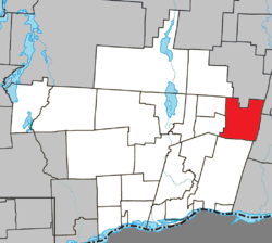 Location within Papineau RCM | |
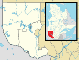 Boileau Location in western Quebec | |
| Coordinates: 45°55′N 74°46′W[1] | |
| Country | Canada |
| Province | Quebec |
| Region | Outaouais |
| RCM | Papineau |
| Constituted | March 8, 1882 |
| Government | |
| • Mayor | Robert Meyer |
| • Federal riding | Argenteuil—Papineau—Mirabel |
| • Prov. riding | Papineau |
| Area | |
| • Total | 141.30 km2 (54.56 sq mi) |
| • Land | 136.33 km2 (52.64 sq mi) |
| Population (2016)[3] | |
| • Total | 335 |
| • Density | 2.5/km2 (6/sq mi) |
| • Pop 2011-2016 | |
| • Dwellings | 407 |
| Time zone | UTC−5 (EST) |
| • Summer (DST) | UTC−4 (EDT) |
| Postal code(s) | J0V 1N0 |
| Area code(s) | 819 |
| Highways | No major routes |
| Website | boileau |
Geography
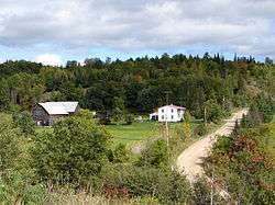
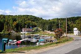
About 30 kilometers (19 mi) north of Montebello, the municipality is characterized by a relief ranging from 182 meters (597 ft) at Philisson Creek to 381 meters (1,250 ft) at the summit of Mont du Cimetière (Mount Cemetery). Sparsely populated, inhabited areas are the hamlets of Brookdale and Boileau and also around the Maskinongé Bay and Loup, Champagneur, and Cross Lakes.[4]
History
The area was first named Ponsonby on the Gale and Duberger map of 1795.[4] In all likelihood, it was named after a town in Cumberland County, England. It is also possible that it was named in honour of any of several noted persons called Ponsonby, including the Postmaster General of Canada of 1784, William Ponsonby (1744-1806).[5]
Settlers were attracted to the area by the nature's beauty and resources. They were generally from Ireland and England, or the nearby villages of Calumet and Grenville. In 1876, the Township of Ponsonby was proclaimed. In 1880, the Parish of Sainte-Valérie was formed, and a year later the Boileau post office opened, named after the first postmaster, Pierre Boileau. In 1882, the Township Municipality of Ponsonby was established.[5]
Because the village was better known as Boileau and Ponsonby was limited to purely administrative use, the municipal authorities, with the support of the majority of the population, were granted the official name change from Ponsonby to Boileau in 1993.[5]
Demographics
| Canada census – Boileau, Quebec community profile | |||
|---|---|---|---|
| 2016 | 2011 | ||
| Population: | 335 (-11.8% from 2011) | 380 (-23.8% from 2006) | |
| Land area: | 136.33 km2 (52.64 sq mi) | 136.50 km2 (52.70 sq mi) | |
| Population density: | 2.5/km2 (6.5/sq mi) | 2.8/km2 (7.3/sq mi) | |
| Median age: | 51.2 (M: 50.0, F: 52.6) | 52.9 (M: 52.4, F: 53.7) | |
| Total private dwellings: | 407 | 425 | |
| Median household income: | $43,392 | $46,038 | |
| References: 2016[6] 2011[7] earlier[8] | |||
| Year | Pop. | ±% |
|---|---|---|
| 1986 | 212 | — |
| 1991 | 217 | +2.4% |
| 1996 | 228 | +5.1% |
| 2001 | 220 | −3.5% |
| 2006 | 499 | +126.8% |
| 2011 | 380 | −23.8% |
| 2016 | 335 | −11.8% |
| Source: Statistics Canada | ||
Mother tongue:[3]
- English as first language: 14.9%
- French as first language: 82.1%
- English and French as first language: 3.0%
- Other as first language: 1.5%
Education
Sir Wilfrid Laurier School Board operates English-language schools:
- Arundel Elementary School in Arundel[9]
- Laurentian Regional High School in Lachute[10]
References
- Reference number 274928 of the Commission de toponymie du Québec (in French)
- Geographic code 80115 in the official Répertoire des municipalités (in French)
- "(Code 2480115) Census Profile". 2016 census. Statistics Canada. 2017.
- "Ponsonby (Canton)" (in French). Commission de toponymie du Québec. Archived from the original on 2016-03-04. Retrieved 2009-01-20.
- "Boileau (Municipalité)" (in French). Commission de toponymie du Québec. Archived from the original on 2016-03-03. Retrieved 2009-01-20.
- "2016 Community Profiles". 2016 Canadian Census. Statistics Canada. February 21, 2017. Retrieved 2020-01-22.
- "2011 Community Profiles". 2011 Canadian Census. Statistics Canada. July 5, 2013. Retrieved 2020-01-22.
- "2001 Community Profiles". 2001 Canadian Census. Statistics Canada. February 17, 2012.
- "Arundel Elementary Zone." Sir Wilfrid Laurier School Board. Retrieved on September 16, 2017.
- "LAURENTIAN REGIONAL HS ZONE." Sir Wilfrid Laurier School Board. Retrieved on September 4, 2017.
External links
![]()
Places adjacent to Boileau, Quebec | |
|---|---|
| Cities | |
|---|---|
| Municipalities | |
| Townships | |
| |
| Authority control |
|
|---|