Moravský Svätý Ján
Moravský Svätý Ján is a village and municipality in Senica District in the Trnava Region of western Slovakia.
Moravský Svätý Ján | |
|---|---|
Village | |
 Former border crossing checkpoint west of the village | |
 Moravský Svätý Ján Location of Moravský Svätý Ján in the Trnava Region  Moravský Svätý Ján Moravský Svätý Ján (Slovakia) | |
| Coordinates: 48°35′00″N 17°01′00″E | |
| Country | Slovakia |
| Region | Trnava |
| District | Senica |
| First mentioned | 1449 |
| Area | |
| • Total | 39.219 km2 (15.143 sq mi) |
| Elevation | 168 m (551 ft) |
| Population (31 December 2005) | |
| • Total | 2,076 |
| • Density | 53/km2 (140/sq mi) |
| Postal code | 908 71 |
| Area code(s) | +421-34 |
| Car plate | SE |
| Website | www.obecmsjan.sk |
| Source:[1] | |
History
In historical records the village was first mentioned in 1449. Under the names SZ.JANOS then ST.JOHANN IN UNGARN in the Austrian Empire.[2] It is ruled by the Kingdom of Hungary until 1918 under the name Morva-Sz-Janos.
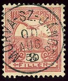
Hungarian stamp cancelled in the village in 1900
Geography
The municipality lies at an altitude of 168 metres and covers an area of 39.219 km². It has a population of about 2074 people.
gollark: It's 0. As you should know, certain electronic component manufacturers developed room temperature/pressure superconductivity decades ago, but strange patent restrictions forbid its use outside of very limited contexts.
gollark: This may make it not technically legal.
gollark: No.
gollark: Fun fact: my unlicensed hovercraft pub is technically legal.
gollark: It's possible that it's invoking a few dark rituals to do so, but you know.
References
- Mestská a obecná štatistika SR
- Handbook of Austria and Lombardy-Venetia Cancellations on the Postage Stamp Issues 1850-1864, by Edwin MUELLER, 1961.
External links
![]()
Municipalities of Senica District | ||
|---|---|---|
| Authority control |
|
|---|
This article is issued from Wikipedia. The text is licensed under Creative Commons - Attribution - Sharealike. Additional terms may apply for the media files.