Cerová
Cerová (Hungarian: Korlátkő) is a village and municipality in Senica District in the Trnava Region of western Slovakia. The village is divided into three parts: Cerová (Hungarian: Czerova), Lieskové (Hungarian: Lészkó), and Rozbehy (Hungarian: Korlátfalva).
Cerová | |
|---|---|
Municipality | |
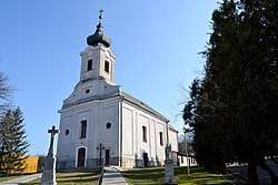
 Church in Cerová | |
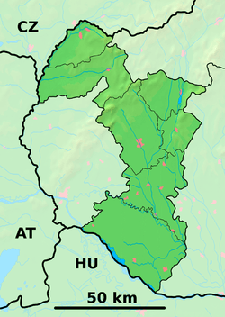
 Cerová Location of Cerová in the Trnava Region  Cerová Cerová (Slovakia) | |
| Coordinates: 48.5883°N 17.3832°E | |
| Country | Slovakia |
| Region | Trnava |
| District | Senica |
| First mentioned | 1696 |
| Area | |
| • Total | 21.880 km2 (8.448 sq mi) |
| Elevation | 248 m (814 ft) |
| Population | |
| • Total | 1,265 |
| • Density | 58/km2 (150/sq mi) |
| Postal code | 906 33 |
| Area code(s) | +421-34 |
| Car plate | SE |
| Website | obeccerova.sk |
History
It was first mentioned in 1324 as Korlathkeu.
Geography
The municipality lies at an altitude of 248 metres and covers an area of 21.880 km2. It has a population of about 1265 people.
Genealogical resources
The records for genealogical research are available at the state archive "Statny Archiv in Bratislava, Slovakia"
- Roman Catholic church records (births/marriages/deaths): 1692-1902 (parish A)
Notable people
- Kaneenika Janakova (born 1970) – ultra-distance runner
gollark: There's a mod for it, EnderNet or something.
gollark: It would be neat if you could transfer items across servers though. Obviously very problematic, but neat.
gollark: I don't think having server admins setting prices is a good idea though.
gollark: I suppose it being cross-server could be interesting.
gollark: I mean, are there not decent economy plugins for servers already?
External links
![]()
- Official page
- https://web.archive.org/web/20071116010355/http://www.statistics.sk/mosmis/eng/run.html
- Surnames of living people in Cerova
region:SK_type:city|display=title}}
This article is issued from Wikipedia. The text is licensed under Creative Commons - Attribution - Sharealike. Additional terms may apply for the media files.