Montsalès
Montsalès is a commune in the Aveyron department in southern France.
Montsalès | |
|---|---|
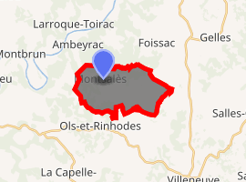
Location of Montsalès 
| |
 Montsalès  Montsalès | |
| Coordinates: 44°29′30″N 1°57′50″E | |
| Country | France |
| Region | Occitanie |
| Department | Aveyron |
| Arrondissement | Villefranche-de-Rouergue |
| Canton | Villeneuvois et Villefranchois |
| Intercommunality | Villeneuvois, Diège et Lot |
| Government | |
| • Mayor (2008–2014) | Benoît Marty |
| Area 1 | 12.47 km2 (4.81 sq mi) |
| Population (2017-01-01)[1] | 330 |
| • Density | 26/km2 (69/sq mi) |
| Time zone | UTC+01:00 (CET) |
| • Summer (DST) | UTC+02:00 (CEST) |
| INSEE/Postal code | 12158 /12260 |
| Elevation | 178–369 m (584–1,211 ft) (avg. 309 m or 1,014 ft) |
| 1 French Land Register data, which excludes lakes, ponds, glaciers > 1 km2 (0.386 sq mi or 247 acres) and river estuaries. | |
Population
| Year | Pop. | ±% |
|---|---|---|
| 1962 | 178 | — |
| 1968 | 219 | +23.0% |
| 1975 | 195 | −11.0% |
| 1982 | 203 | +4.1% |
| 1990 | 199 | −2.0% |
| 1999 | 215 | +8.0% |
| 2008 | 239 | +11.2% |
gollark: Do you mean "inertial"?
gollark: 8km/s fast.
gollark: Things in orbit are already fast, actually.
gollark: Inertial guidance or whatever probably less so, at the accelerations it'd have to deal with.
gollark: Accurate orbital prediction is as far as I know basically a solved problem, GPS relies on it.
See also
References
- "Populations légales 2017". INSEE. Retrieved 6 January 2020.
| Wikimedia Commons has media related to Montsalès. |
This article is issued from Wikipedia. The text is licensed under Creative Commons - Attribution - Sharealike. Additional terms may apply for the media files.