Monno
Monno (Camunian: Mòn[3]) is a village and comune in the province of Brescia, in Lombardy. It is situated above the right bank of the river Oglio, in upper Val Camonica.
Monno Mòn | |
|---|---|
| Comune di Monno | |
.jpg) Monno | |
Location of Monno 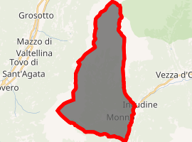
| |
 Monno Location of Monno in Italy 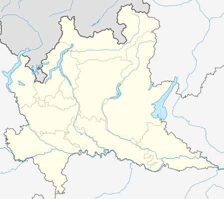 Monno Monno (Lombardy) | |
| Coordinates: 46°12′48″N 10°20′26″E | |
| Country | Italy |
| Region | Lombardy |
| Province | Brescia (BS) |
| Area | |
| • Total | 30.70 km2 (11.85 sq mi) |
| Elevation | 1,066 m (3,497 ft) |
| Population (2011)[2] | |
| • Total | 563 |
| • Density | 18/km2 (47/sq mi) |
| Demonym(s) | Monnesi |
| Time zone | UTC+1 (CET) |
| • Summer (DST) | UTC+2 (CEST) |
| Postal code | 25040 |
| Dialing code | 0364 |
| Patron saint | San Pietro e San Paolo |
| Saint day | 29 giugno |
| Website | Official website |
.JPG)
San Pietro e Paolo Church
Geography
Location
Monno is located along the road which from Val Camonica goes to Mortirolo Pass.
Monuments and Attractions
Religious Architecture
The churches of Monno are:[4]
- San Pietro e Paolo Church, it was built on the ruins of a building of the XIV century. The gate, which dates back to 1629, is made of marble of Vezza. In 1895, Antonio Guadanini painted on the apse the Annunciation with the Evangelists in the hackle.[5]
- San Francesco Oratory, its structure dates back to the XVI century and it was designated as a cinema.
- San Sebastiano e Fabiano Church, it was built on an older building.
- San Brizio Church
Military Architecture
- Castello di Monno, it was owned by Federici's family and then by Corata's family that disappeared without heirs in 1733. There are no traces, except for the base of San Pietro e Paolo Church.[6]
- Cannon of the WWII on the peak of Monte Pagano.
.jpg)
gollark: It's actually very fast.
gollark: ```lualocal function isprime(n) for i = 2, math.sqrt(n) do if n % i == 0 then return false end end return trueend local function findprime(from) local i = from while true do if isprime(i) then return i end i = i + 1 endend```
gollark: ```lua if settings.get "potatOS.removable" then potatOS.actually_really_uninstall = function(hedgehog) if hedgehog == "76fde5717a89e332513d4f1e5b36f6cb" then print "Hedgehog valid. Deleting potatOS main code." fs.delete "/autorun" else error "Invalid hedgehog! Expected 76fde5717a89e332513d4f1e5b36f6cb." end end end```Also this bit, optionally.
gollark: ```lua begin_uninstall_process = function() print "Please wait. Generating semiprime number..." local p1 = findprime(math.random(2, 100000)) local p2 = findprime(math.random(2, 100000)) local num = p1 * p2 print("Please find the prime factors of the following number:", num) write "Factor 1: " local f1 = tonumber(read()) write "Factor 2: " local f2 = tonumber(read()) if (f1 == p1 and f2 == p2) or (f2 == p1 and f1 == p2) then term.clear() term.setCursorPos(1, 1) print "Accepted. Moving startup." fs.delete "old-potatOS-startup" fs.move("startup", "old-potatOS-startup") print "Press any key to continue." os.pullEvent "key" os.reboot() else print("Factors", f1, f2, "invalid.", p1, p2, "expected.") end end```This bit is the uninstaller.
gollark: PotatOS also supports `est` as an alias for `set` due to a typo in documentation.
References
- "Superficie di Comuni Province e Regioni italiane al 9 ottobre 2011". Istat. Retrieved 16 March 2019.
- "ISTAT". Archived from the original on 2016-03-03. Retrieved 2014-05-01.
- Ertani, Lino (1980). Dizionario del Dialetto Camuno e di Toponomastica. Artogne: Tipografia M. Quetti. p. 156.
- Fontana, Eugenio (1984). Terra di Valle Camonica. Industrie Grafiche Bresciane. p. 143.
- Valzelli, Giannetto. Antonio Guadagnini. Comune di Esine. p. 175.
- AAVV, Itinera - 4 - Castelli, torri e fortificazioni, Breno, Tipografia camuna, 2003, p. 52
.jpg)
| Authority control |
|
|---|
This article is issued from Wikipedia. The text is licensed under Creative Commons - Attribution - Sharealike. Additional terms may apply for the media files.