Mongar District
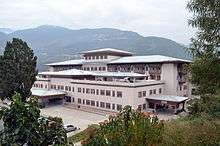
Mongar District (Dzongkha: མོང་སྒར་རྫོང་ཁག་; Wylie: Mong-sgar rdzong-khag) is one of the 20 dzongkhags (districts) comprising Bhutan. Mongar is the fastest-developing dzongkhag in eastern Bhutan. A regional hospital has been constructed and the region is bustling with many economic activities. Mongar is noted for its lemon grass, a plant that can be used to produce an essential oil. It also has a hydroelectric power-plant on the Kuri Chhu river.
Mongar district མོང་སྒར་རྫོང་ཁག | |
|---|---|
District | |
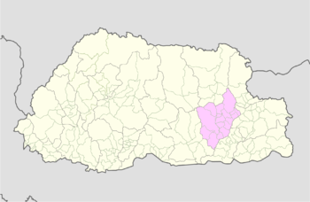
 Map of Mongar District in Bhutan | |
| Country | |
| District | Mongar District |
| Area | |
| • Total | 2,859 km2 (1,104 sq mi) |
| Elevation | 1,600 m (5,200 ft) |
| Population (2017) | |
| • Total | 37,150 |
| • Density | 13/km2 (34/sq mi) |
| Time zone | UTC+6 (BTT) |
| HDI (2017) | 0.619[1] medium · 6th |
| Website | www |
Languages


Mongar is home to a variety of Bhutanese languages and dialects. In the east, the East Bodish Tshangla (Sharchopkha) is the dominant language, also used as a regional lingua franca.[2]
Central Mongar is the only region where the East Bodish Chali language is spoken, by about at total of 8,200 people in Wangmakhar, Gorsum and Tormazhong villages, mainly in and around Chhali Gewog on the east bank of the Kuri Chhu River.[2]
Southern Mongar is likewise unique for its 1,000 Gongduk speakers living in a few inaccessible villages of Gongdue Gewog near the Kuri Chhu river. The language appears to be the sole representative of a unique branch of the Tibeto-Burman language family [3] and retains the complex verbal agreement system of Proto-Tibeto-Burman.[4]
In southwestern Mongar, residents speak Khengkha, an East Bodish language closely related to Bumthangkha languages including Kurtöp. Bumthangkha itself is also spoken by the natives of extreme northwest Mongar. Residents of the Kuri Chhu valley of northern Mongar speak Chochangachakha language, a Central Bodish language very closely related to Dzongkha, the national language.[2][5][6][7][8]
Geography
The Western Mongar District contains part of the Thrumshingla National Park (the gewogs of Saling and the Tsamang) and the northeastern Mongar District contains part of the Bumdeling Wildlife Sanctuary (the gewog of Sharmung).[9][10]
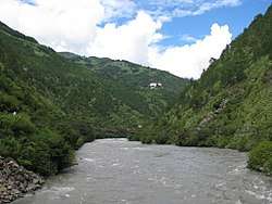
The Kuri Chhu river flows through the Mongar District valley. The Kuri Chhu, a major river of eastern Bhutan, is a tributary of the Manas River system, which is the largest river in Bhutan and a major tributary of the Brahmaputra River, the waterway that drains most of the eastern region. [11]

References
- "Sub-national HDI - Area Database - Global Data Lab". hdi.globaldatalab.org. Retrieved 2018-09-13.
- van Driem, George L. (1993). "Language Policy in Bhutan". London: SOAS. Archived from the original (PDF) on 2010-11-01. Retrieved 2011-01-18.
- Himalayan Languages Project. "Gongduk". Himalayan Languages Project. Archived from the original on 2012-03-03. Retrieved 2009-11-06.
- Ethnologue. "Gongduk: A language of Bhutan". SIL International. Retrieved 2009-11-06.
- "Chalikha". Ethnologue Online. Dallas: SIL International. 2006. Retrieved 2011-01-18.
- "Chocangacakha". Ethnologue Online. Dallas: SIL International. 2006. Retrieved 2011-01-18.
- "Bumthangkha". Ethnologue Online. Dallas: SIL International. 2006. Retrieved 2011-01-18.
- van Driem, George (2007). Matthias Brenzinger (ed.). Language diversity endangered. Trends in linguistics: Studies and monographs, Mouton Reader. 181. Walter de Gruyter. p. 312. ISBN 3-11-017050-7.
- "Chiwogs in Mongar" (PDF). Election Commission, Government of Bhutan. 2011. Archived from the original (PDF) on 2011-10-02. Retrieved 2011-07-28.
- "Parks of Bhutan". Bhutan Trust Fund for Environmental Conservation online. Bhutan Trust Fund. Archived from the original on 2012-03-21. Retrieved 2011-03-26.
- "Eastern Bhutan" (PDF). Lonely Planet. Archived from the original (PDF) on 2011-06-07. Retrieved 2010-05-09.