Trongsa District
Trongsa District (Dzongkha: ཀྲོང་གསར་རྫོང་ཁག་; Wylie transliteration: Krong-gsar rdzong-khag) is one of the districts of Bhutan. It is the most central district of Bhutan and the geographic centre of Bhutan is located within it at Trongsa Dzong.
Trongsa district ཀྲོང་གསར་རྫོང་ཁག | |
|---|---|
District | |
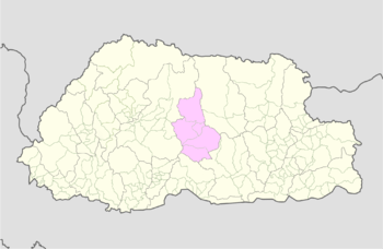
 Map of Trongsa District in Bhutan | |
| Country | Bhutan |
| Headquarters | Trongsa |
| Area | |
| • Total | 1,807 km2 (698 sq mi) |
| Population (2017) | |
| • Total | 19,960 |
| • Density | 11/km2 (29/sq mi) |
| Time zone | UTC+6 (BTT) |
| HDI (2017) | 0.619[1] medium · 6th |
| Website | www |
Languages

Trongsa is a linguistically diverse district. In the north and east inhabitants speak Bumthangkha, and in the extreme southeast Khengkha is spoken. Nyenkha is spoken in the western half of the district, straddling the border with Wangdue Phodrang District. To the north, along and across the same border, live speakers of Lakha. In the extreme south, the national language Dzongkha is spoken. Across the mid-south, tiny communities of autochthonous 'Olekha (Black Mountain Monpa) speakers have all but disappeared.[2]
Historically, Bumthangkha and its speakers have had close contact with speakers of Kurtöpkha, Mangduepikha and Khengkha, nearby languages of central and eastern Bhutan, to the extent that they may be considered part of a wider collection of "Bumthang languages." Nyenkha, also related to the Bumthang languages, is more divergent while 'Olekha is only distantly related.[3][4][5]
Geography
Trongsa District is bordered by Wangdue Phodrang District to the west and Bumthang District to the east. To the south it borders Tsirang, Sarpang, and Zhemgang Districts .
Environment
Most of Trongsa Districts is environmentally protected. Wangchuck Centennial Park in the north (the gewog of Nubi) and Jigme Singye Wangchuck National Park in central, western, and southern Trongsa (the gewogs of Langthil and Tangsibji) are connected by biological corridors, all of which are protected areas of Bhutan. Biological corridors also occupy substantial portions of the southeast and northeast, leading to Thrumshingla National Park in neighboring districts.[6][7]
See also
References
- "Sub-national HDI - Area Database - Global Data Lab". hdi.globaldatalab.org. Retrieved 2018-09-13.
- van Driem, George L. (1993). "Language Policy in Bhutan" (PDF). London: SOAS. Retrieved 2011-01-18.
- Schicklgruber, Christian (1998). Françoise Pommaret-Imaeda (ed.). Bhutan: Mountain Fortress of the Gods. Shambhala. pp. 50, 53.
- van Driem, George (2007). "Endangered Languages of Bhutan and Sikkim: East Bodish Languages". In Moseley, Christopher (ed.). Encyclopedia of the World's Endangered Languages. Routledge. p. 295. ISBN 0-7007-1197-X.
- van Driem, George (2007). Matthias Brenzinger (ed.). Language diversity endangered. Trends in linguistics: Studies and monographs, Mouton Reader. 181. Walter de Gruyter. p. 312. ISBN 3-11-017050-7.
- "Chiwogs in Trongsa" (PDF). Election Commission, Government of Bhutan. 2011. Archived from the original (PDF) on 2011-10-02. Retrieved 2011-07-28.
- "Parks of Bhutan". Bhutan Trust Fund for Environmental Conservation online. Bhutan Trust Fund. Archived from the original on 2011-07-02. Retrieved 2011-03-26.