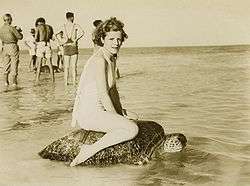
Mon Repos, Queensland
Mon Repos is a coastal locality in the Bundaberg Region, Queensland, Australia.[1] It has a low population.
| Mon Repos Queensland | |||||||||||||||
|---|---|---|---|---|---|---|---|---|---|---|---|---|---|---|---|
 Mon Repos | |||||||||||||||
| Coordinates | 24°48′17″S 152°26′25″E | ||||||||||||||
| Postcode(s) | 4670 | ||||||||||||||
| Location | |||||||||||||||
| LGA(s) | Bundaberg Region | ||||||||||||||
| State electorate(s) | Burnett | ||||||||||||||
| Federal Division(s) | Hinkler | ||||||||||||||
| |||||||||||||||

Geography
Most of the coastline of Mon Repos is part of the Mon Repos Conservation Park, established to protect the nesting areas of turtles. Inland of the conversation park, much of the land is state reserves or subject to other restrictions designed to support the wildlife objectives of the conversation park. There is a small amount of built environment, a caravan park on the coast and a small residential area inland from it.[2]
History
Mon Repos is French for "My Rest" and was the name of the homestead established by Augustus Purling Barton in the early 1880s.[3][4]
In the 1890s, the governments of France, Queensland and New South Wales decided to construct an undersea telegraph cable to link Australia to North America across the Pacific Ocean via New Caledonia, Fiji, Samoa, and Hawaii. The cable came ashore at Mon Repos, where a cable station was constructed. The cable was used until the 1920s when it was replaced by a radio service via Sydney and the cable station demolished. The cables remained in place under the sea where they were used during World War II by the Royal Australian Navy to train crews in midget submarines operating from HMS Bonaventure to cut cables in preparation to cut undersea telephone cables in Tokyo. Two lieutenants Bruce Enzer and Bruce Carey died during the training. Some remains of the cable station can be seen within the caravan park.[5]
Heritage listings
Mon Repos has a number of heritage-listed sites, including:
- Grange Road: South Sea Islander Wall[6]
References
- "Mon Repos (entry 44747)". Queensland Place Names. Queensland Government. Retrieved 9 November 2015.
- "Queensland Globe". State of Queensland. Retrieved 9 November 2015.
- "South Sea Islander Wall (entry 602230)". Queensland Heritage Register. Queensland Heritage Council. Retrieved 1 August 2014.
- "Family Notices". Maryborough Chronicle, Wide Bay and Burnett Advertiser (Qld. : 1860 – 1947). Qld.: National Library of Australia. 5 January 1885. p. 2. Retrieved 11 November 2015.
- "Mon Repos Cable Station Remains" (PDF). Bundaberg Regional Council. Archived (PDF) from the original on 6 January 2016. Retrieved 11 November 2015.
- "South Sea Islander Wall (entry 602230)". Queensland Heritage Register. Queensland Heritage Council. Retrieved 7 July 2013.
External links
![]()