North Isis
North Isis is a locality in the Bundaberg Region, Queensland, Australia.[1]
| North Isis Queensland | |||||||||||||||
|---|---|---|---|---|---|---|---|---|---|---|---|---|---|---|---|
 North Isis | |||||||||||||||
| Coordinates | 25.1733°S 152.2705°E | ||||||||||||||
| Postcode(s) | 4660 | ||||||||||||||
| Area | 81.8 km2 (31.6 sq mi) | ||||||||||||||
| LGA(s) | Bundaberg Region | ||||||||||||||
| State electorate(s) | Burnett | ||||||||||||||
| Federal Division(s) | Hinkler | ||||||||||||||
| |||||||||||||||
Geography
The Bruce Highway touches the south-west boundary of North Isis (but does not enter it). At this point, the Isis Highway splits off and passes through the south-west corner of the locality and then forms the western boundary of the locality.[2]
The locality is predominantly used for farming, mostly of sugarcane. There is a network of cane tramways in the locality.[2]
History
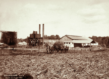
North Isis Sugar Mill, 1896
Isis North Provisional School opened on 29 August 1887. On 1 June 1898 it became Isis North State School. It closed on 13 April 1942.[3]
A sugar mill opened in North Isis on Knockroe Road circa 1894.[4] It had ceased operation before 1931.[5]
Whitebridge State School opened on 1915 and closed on 1921.[3]
gollark: ~play here comes science elements
gollark: ~play here comes science
gollark: ~play e
gollark: ~play rickroll again
gollark: no.
References
- "North Isis - locality in Bundaberg Region (entry 47654)". Queensland Place Names. Queensland Government. Retrieved 3 August 2017.
- "Queensland Globe". State of Queensland. Retrieved 3 August 2017.
- Queensland Family History Society (2010), Queensland schools past and present (Version 1.01 ed.), Queensland Family History Society, ISBN 978-1-921171-26-0
- "THE SUGAR INDUSTRY". The Capricornian. 20 (9). Queensland, Australia. 3 March 1894. p. 35. Retrieved 3 August 2017 – via National Library of Australia.
- "QUEENSLAND SUGAR". Townsville Daily Bulletin. LIII (108). Queensland, Australia. 6 May 1931. p. 11. Retrieved 3 August 2017 – via National Library of Australia.
This article is issued from Wikipedia. The text is licensed under Creative Commons - Attribution - Sharealike. Additional terms may apply for the media files.