Mizuho-ku, Nagoya
Mizuho (瑞穂区, Mizuho-ku) is one of the 16 wards of the city of Nagoya in Aichi Prefecture, Japan. As of 1 October 2019, the ward had an estimated population of 107,622 and a population density of 9,592 persons per km². The total area was 11.22 km².
Mizuho 瑞穂区 | |
|---|---|
| Mizuho Ward | |
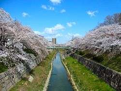 Yamazaki River | |
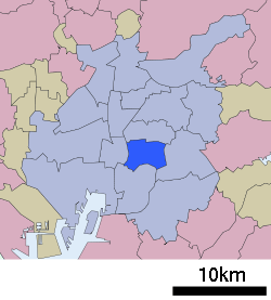 Location of Mizuho-ku in Nagoya | |
 Mizuho | |
| Coordinates: 35°07′54″N 136°56′06″E | |
| Country | Japan |
| Region | Tōkai region Chūbu region |
| Prefecture | Aichi |
| Area | |
| • Total | 11.22 km2 (4.33 sq mi) |
| Population (October 1, 2019) | |
| • Total | 107,622 |
| • Density | 9,600/km2 (25,000/sq mi) |
| Time zone | UTC+9 (Japan Standard Time) |
| - Tree | Cherry blossom |
| - Flower | Cherry blossom [1] |
| Phone number | 052-841-1521 |
| Address | 3-23 Mizuho-dori, Mizuho-ku, Nagoya-shi, Aichi-ken 467-8531 |
| Website | www |
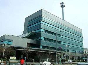
Mizuho-ku Ward Office
Geography
Mizuho Ward is located near the geographic center of Nagoya city.
Surrounding municipalities
- Showa Ward
- Atsuta Ward
- Tempaku Ward
- Minami Ward
History
Mizuho District was established on February 11, 1944 from the eastern portion of Atsuka-ku.
Transportation
Railroads
- Meitetsu - Nagoya Main Line
- Nagoya Municipal Subway - Sakura-dōri Line
Local attractions
- Nagoya City Museum
- Mizuho Kofun Group
- Mizuho rugby stadium.
gollark: Autocrafting!
gollark: Oh, no, worse than that.
gollark: Because Chisel, each biome variant of wood has 16 texture variants.
gollark: https://pastebin.com/xj2j5x6Z
gollark: Well, the substitution list for wood is too long to fit.
References
- 瑞穂区の紹介 (in Japanese). Nagoya City. 1 October 2007.
| Wikimedia Commons has media related to Mizuho-ku, Nagoya. |
Nagoya (capital) | ||||
| Nagoya |
| |||
| Core cities | ||||
| Special cities | ||||
| Cities | ||||
| Districts | ||||
| Authority control |
|
|---|
This article is issued from Wikipedia. The text is licensed under Creative Commons - Attribution - Sharealike. Additional terms may apply for the media files.