Milmersdorf
Milmersdorf is a municipality in the Uckermark district, in Brandenburg, Germany.
Milmersdorf | |
|---|---|
Location of Milmersdorf within Uckermark district  | |
 Milmersdorf  Milmersdorf | |
| Coordinates: 53°07′00″N 13°39′00″E | |
| Country | Germany |
| State | Brandenburg |
| District | Uckermark |
| Municipal assoc. | Gerswalde |
| Government | |
| • Mayor | Klaus-Christian Arndt (SPD) |
| Area | |
| • Total | 62.86 km2 (24.27 sq mi) |
| Elevation | 60 m (200 ft) |
| Population (2018-12-31)[1] | |
| • Total | 1,426 |
| • Density | 23/km2 (59/sq mi) |
| Time zone | CET/CEST (UTC+1/+2) |
| Postal codes | 17268 |
| Dialling codes | 039886 |
| Vehicle registration | UM |
| Website | www.amt-gerswalde.de |
Demography
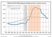
Development of population since 1875 within the current boundaries (Blue line: Population; Dotted line: Comparison to population development of Brandenburg state; Grey background: Time of Nazi rule; Red background: Time of communist rule)
|
|
|
gollark: My AP egg is showing "accepting aid" on it.
gollark: <@!284397085959258112> It was you who liked prizekins, right? Prizekin.
gollark: The plural is of course khusæ,
gollark: Turns out I have this dragon from XFile: https://dragcave.net/lineage/qrO75
gollark: There is no escape.
References
- "Bevölkerung im Land Brandenburg nach amtsfreien Gemeinden, Ämtern und Gemeinden 31. Dezember 2018". Amt für Statistik Berlin-Brandenburg (in German). July 2019.
- Detailed data sources are to be found in the Wikimedia Commons.Population Projection Brandenburg at Wikimedia Commons
Towns and municipalities in Uckermark | ||
|---|---|---|
| Coat of Arms of Uckermark district | |
| Wikimedia Commons has media related to Milmersdorf. |
| Authority control |
|
|---|
This article is issued from Wikipedia. The text is licensed under Creative Commons - Attribution - Sharealike. Additional terms may apply for the media files.