Gramzow
Gramzow is a municipality in the Uckermark district, in Brandenburg, Germany.
Gramzow | |
|---|---|
Location of Gramzow within Uckermark district 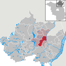 | |
 Gramzow  Gramzow | |
| Coordinates: 53°13′00″N 14°00′00″E | |
| Country | Germany |
| State | Brandenburg |
| District | Uckermark |
| Municipal assoc. | Gramzow |
| Government | |
| • Mayor | Karl Heimann |
| Area | |
| • Total | 65.67 km2 (25.36 sq mi) |
| Elevation | 65 m (213 ft) |
| Population (2018-12-31)[1] | |
| • Total | 1,836 |
| • Density | 28/km2 (72/sq mi) |
| Time zone | CET/CEST (UTC+1/+2) |
| Postal codes | 17291 |
| Dialling codes | 039861 |
| Vehicle registration | UM |
| Website | www.amtgramzow.de |
Demography
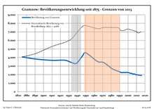
Development of Population since 1875 within the Current Boundaries (Blue Line: Population; Dotted Line: Comparison to Population Development of Brandenburg state; Grey Background: Time of Nazi rule; Red Background: Time of Communist rule)
|
|
|
gollark: Against "AI" v2? Worrying.
gollark: It's meant to. I don't know why it doesn't.
gollark: I have now dethingied the GIF and can see all images. There are 50.
gollark: Yes, that UI has been improved.
gollark: https://osmarks.net/ttt/
References
- "Bevölkerung im Land Brandenburg nach amtsfreien Gemeinden, Ämtern und Gemeinden 31. Dezember 2018". Amt für Statistik Berlin-Brandenburg (in German). July 2019.
- Detailed data sources are to be found in the Wikimedia Commons.Population Projection Brandenburg at Wikimedia Commons
Towns and municipalities in Uckermark | ||
|---|---|---|
| Coat of Arms of Uckermark district | |
| Wikimedia Commons has media related to Gramzow (Uckermark). |
| Authority control |
|
|---|
This article is issued from Wikipedia. The text is licensed under Creative Commons - Attribution - Sharealike. Additional terms may apply for the media files.