Metro A Line (Minnesota)
The METRO A Line is a bus rapid transit line in the Twin Cities, Minnesota operated by Metro Transit. The A Line operates primarily along the Snelling Avenue corridor and travels through the cities of Minneapolis, Saint Paul, Falcon Heights, and Roseville. From the Blue Line in Minneapolis, the line travels past Minnehaha Park, through the Highland Village commercial area, past Macalester College, and connects to the Green Line near Allianz Field. The line continues through Saint Paul, past Hamline University, before traveling through Falcon Heights and Roseville, where the line passes the Minnesota State Fairgrounds, Har Mar Mall, and terminates at Rosedale Center.
While lacking dedicated bus lanes typically associated with bus rapid transit, there are many features that improve the speed and reliability of the line. Specially designed buses stop only at stations spaced roughly .5 miles (0.80 km) apart. Buses have wider doors and allow entry at all doors because fares are collected in advance at machines located at stations. Station shelters also have light, heat, and real-time arrival signs. Many intersections along the line have transit signal preemption, which in combination with all of the other features of the line, improved travel times in the corridor by 25%.
Transit has operated in the corridor since 1905 when streetcars began operating until they were replaced by buses in 1952. In the mid-2000s the Met Council began making plans for upgraded urban core local bus routes, which it called arterial bus rapid transit. A study completed in 2012 found the A Line corridor to be the best suited in the region for the first project and after delays and construction setbacks, the line opened in 2016 at a cost of $27 million. Ridership in the corridor has increased roughly 33% since opening. In 2018 the A Line carried an average of 4,860 passengers per weekday, and by 2030, the A Line is expected to carry 8,000 passengers per day.[2][1]
Route description
The A Line's southern terminus is at the 46th Street station of the Metro Blue Line. At the station are connections to 4 Metro Transit routes and 2 Minnesota Valley Transit Authority routes. A Line buses travel east along 46th St, cross Minnesota State Highway 55, also known as Hiawatha Avenue, before passing near Minnehaha Park. E 46th St becomes Ford Parkway and crosses the Mississippi River on the Intercity Bridge which is just north of the Mississippi River's Lock and Dam No. 1. On the other side of the bridge the line enters the city of Saint Paul and passes by the former Twin Cities Assembly Plant which is currently being redeveloped into housing and commercial properties.[3] Ford Parkway continues through the Highland Village commercial node in Highland Park, Saint Paul where there are connections to 7 Metro Transit bus routes, until reaching Snelling Avenue next to the Highland Park Tower. After turning north on Snelling, the line travels by Macalester College in the Macalester-Groveland neighborhood before passing Grand Avenue and Summit Avenue. While traveling through the Merriam Park neighborhood of Saint Paul the line passes a future connection to the Metro B Line near Selby Avenue.[4] After crossing Interstate 94, the line passes Allianz Field and the Midway shopping area in the Hamline Midway neighborhood. A connection to the Green Line at the Snelling Avenue station along University Avenue is available. The line continues north past Hamline University, the Minnesota State Fairgrounds, and the Como Park neighborhood of Saint Paul. The line enters Falcon Heights, Minnesota and passes Larpenteur Avenue before passing by the Har Mar Mall in Roseville, Minnesota. The line crosses Minnesota State Highway 36 before terminating at Rosedale Center where there are connections to 8 Metro Transit bus routes.[5][6]
Service
| Type | Frequency | Span of service | |
|---|---|---|---|
| Days | Times | ||
| Mornings | 15-30 minutes | Monday–Friday | 4:00 a.m. – 6:00 am |
| Weekdays | 10 minutes | Monday–Friday | 6:00 a.m. – 7:00 pm |
| Evenings | 15-30 minutes | Monday–Friday | 7:00 p.m. – 1:00 am |
| Saturday | 10-30 minutes | Saturday | 4:00 a.m. – 1:00 am |
| Sunday | 10-30 minutes | Sunday | 4:30 a.m. – 1:00 am |
The A Line runs every 10 minutes during daytime service on weekdays and weekends, with reduced frequencies of up to 30 minutes in the early morning and late evening.[7] Route 84, which previously served the Snelling Avenue corridor, was retained with 30-minute service to provide connections from the corridor to other areas.[8] When the Green Line opened in 2014, just the Snelling Avenue portion of the route had 10-minute service. After the opening of the A Line, the entire corridor had 10-minute service which was part of an increase of 63,300 to 80,900 annual service hours.[9] Estimated annual operating costs are $4.2 million.[10]
Ridership in the corridor, which combines the A Line and Route 84, rose from 3,800 weekday rides to 5,100 weekday rides over the same time period in the first month after opening.[11] In the overall first year of operation, ridership in the corridor increased by 30%.[9] The A Line served almost 1.7 million rides in 2019 which was a 3 percent increase from the year before.[12]
Features
The A Line utilizes several bus rapid transit features that result in service that is 6 to 8 minutes faster than existing buses on Snelling Avenue. Transit signal priority is installed at 19 of the 34 traffic signals on the line, which has improved reliability on the line.[2][13] The corridor lacks bus lanes which are typical for many bus rapid transit lines because of likely neighborhood opposition.[14] Metro Transit maintains that dedicated bus lanes would not have sped up travel times significantly due to most speed improvement being linked to other A Line design features that minimized red light and passenger delay.[15] Previously buses spent around 24% of their time waiting at signals and had a 90.7% on-time performance.[16][17] Stations are spaced at roughly .5-mile (0.80 km) intervals which helps limit the time spent on accelerating and stopping the bus.[18]
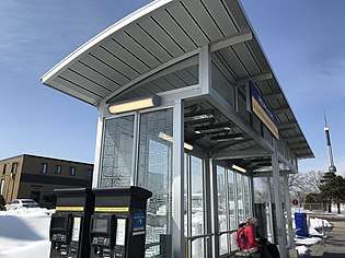
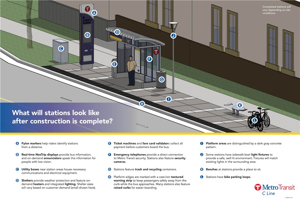
Stations on the A Line have enhanced features to differentiate them from local bus stops. Station shelters follow a "kit-of-parts" design so they can be easily identified and used throughout Metro's bus rapid transit system.[19] There are three different station sizes–small, medium, and large–and the size chosen depends on daily boardings and site context. Stations have lighted canopies, on-demand heating, security cameras and emergency telephones, benches, and bike parking. Pavement in boarding areas are treated with a darker shade of concrete to delineate them from the sidewalk. Ticket vending machines and Go-To card readers are located on platforms for off-board fare collection, speeding up the boarding process and reducing bus dwell time. Each station has a pylon marker that provides real-time bus arrival information and station identification. Illuminated signage at the top of the station blinks when a bus is one minute away. Curbs at stations have tactile warning strips and are raised 9 in (23 cm) from the road surface, facilitating near-level boarding to speed up and make boarding easier.[20][21][8] To increase travel speed and reduce delay related to pulling in and out of traffic while stopping, stations are located far-side of intersections and curbs are extended out to the travel lane where buses stop to board passengers.[22]
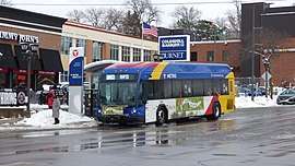
Buses on the A Line have wider rear doors which in combination with all-door boarding, allows for reduced dwell time when passengers are boarding or alighting. There is no fare collection equipment on board due to off-board fare payment machines located at stations. 12 new buses were purchased for the line at a cost of $500,000 each, which is roughly 10% greater than a normal bus.[23][24] Buses used on the A Line have more standing room than other Metro Transit buses, stainless steel seat frames, and provide free on-board Wi-Fi.[23][25] Buses have a unique exterior paint scheme from other Metro Transit vehicles, rounded exterior molding edges, and brighter digital displays.[26] Initially 12 buses were purchased for the line with 3 being new buses and 9 being replacement buses from an existing contract with Gillig.[27] An additional bus was purchased a month after the line opened to improve maintenance and reliability operations.[28]
The passenger experience and legibility of the line helped it be described as "probably the best bus route in the US" by one transit expert.[29][30][31] Riders are more satisfied with the A Line's service than regular route local bus service.[9] Six police officers were added to the Metro Transit Police Department to monitor buses and check tickets.[23]
Stations
| Station[5] | ID[32] | City | Connections [5] | Opened | 2018 Ridership[33] | |
|---|---|---|---|---|---|---|
| Rosedale Transit Center | 52531 | Roseville | Many routes | June 11, 2016 | 1,428 | |
| Snelling & County Road B | 50013, 50015 | Roseville | 65 | June 11, 2016 | 371 | |
| Snelling & Larpenteur | 50032, 50010 | Falcon Heights | 61 | June 11, 2016 | 261 | |
| Snelling & Hoyt | 56120, 56121 | Falcon Heights & Saint Paul | No routes | June 11, 2016 | 93 | |
| Snelling & Como | 931, 56119 | Saint Paul | 3, 84 | June 11, 2016 | 235 | |
| Snelling & Hewitt | 15114, 18508 | Saint Paul | 84 | June 11, 2016 | 152 | |
| Snelling & Minnehaha | 18875, 56118 | Saint Paul | 67, 84 | June 11, 2016 | 238 | |
| Snelling & University | 56117, 56122 | Saint Paul | Green Line, 16, 21, 84 | June 11, 2016 | ||
| Snelling & Dayton | 17307, 17371 | Saint Paul | 21, 53, 84 | June 11, 2016 | 237 | |
| Snelling & Grand | 17312, 17366 | Saint Paul | 63, 84 | June 11, 2016 | 376 | |
| Snelling & St. Clair | 17318, 56116 | Saint Paul | 70, 84 | June 11, 2016 | 118 | |
| Snelling & Randolph | 56123, 56115 | Saint Paul | 74, 84 | June 11, 2016 | 273 | |
| Snelling & Highland | 17332, 56114 | Saint Paul | 84 | June 11, 2016 | 133 | |
| Ford & Fairview | 56124, 56113 | Saint Paul | 84 | June 11, 2016 | 55 | |
| Ford & Kenneth | 56125 , 4283 | Saint Paul | 23, 46, 70, 74, 84, 87, 134 | June 11, 2016 | 148 | |
| Ford & Finn | 56126, 56112 | Saint Paul | 23, 46, 70, 74, 84, 87, 134 | June 11, 2016 | 234 | |
| Ford & Woodlawn | 56127, 56111 | Saint Paul | 23, 46, 74 | June 11, 2016 | 51 | |
| 46th Street & 46th Avenue | 56128, 56114 | Minneapolis | 23, 46, 74 | June 11, 2016 | 51 | |
| 46th Street & Minnehaha | 16607, 53362 | Minneapolis | 7, 9, 46, 74 | June 11, 2016 | 52 | |
| 46th Street station | 51544 | Minneapolis | 7, 9, 46, 74; 436, 446 | June 11, 2016 | ||
| Timepoint or terminus | ||||||
History
Streetcars ran along Snelling Avenue from 1905 until 1952. The line was an important crosstown connection to many other streetcar lines. The Snelling streetcar line did not travel north of Larpenteur Avenue and instead traveled closer to Como Park along Como Ave, Pascal Ave, Arlington Ave, and Hamline Ave. In 1947 a shuttle bus began to run from Snelling and Como Avenues, north past Larpenteur Avenue to Roselawn Avenue in Roseville. The bus service was extended and connected with the replacement bus service along Snelling Avenue that was instituted in 1952 when streetcars no longer ran the route. At its peak, the Twin City Rapid Transit Company ran 10-minute peak, and 15-minute offpeak service on the corridor.[34] The Snellling Streetcar Shops and then later Snelling Bus Garage, both located at the intersection of Snelling and University Avenues, served many transit routes in the area including service along Snelling Avenue.[35] Portions of the Snelling Streetcar Shops were turned into a shopping center and the Snelling Bus Barn was torn down in 2001.[36] Allianz Field was later constructed on portions of the former bus barn.
Return of streetcars to the corridor has been studied. In 2001, a neighborhood plan for Macalester Groveland encouraged study of a streetcar along Snelling.[37] The City of Saint Paul along with consultants conducted a $250,000 study of creating streetcar network for the city in 2012-2014.[38] Snelling Avenue as a corridor by itself was one of the five best transit corridors for streetcars, partially due to the transit supportive land use. Pairing a Snelling Avenue streetcar with a route along Ford Parkway was also suggested as a possibility.[37] A streetcar line along the length of Snelling Avenue was not proposed on the long-term network but a portion of Snelling between Hamline University to Selby Avenue was selected as a potential corridor. A Snelling + Ford Parkway streetcar corridor from 46th Street Station to the Green Line and a Snelling North corridor from the Green Line to Como Park scored lower on the study's screening criteria due to lower ridership, less transit supportive land use, and limited potential to redevelop properties.[39] The Snelling + Selby Corridor was not selected as an initial starter line.[40]
| Route 84 | Route 144 | |||
|---|---|---|---|---|
| Weekday Service Hours/Rides | 93.7 | 3,879 | 8.9 | 455 |
| Saturday Service Hours/Rides | 74.9 | 3,379 | - | - |
| Sunday Service Hours/Rides | 36.4 | 1,850 | - | - |
| Operating Costs | $4,741,185 | $467,693 | ||
| Fares | $945,430 | $197,142 | ||
| Subsidy per ride | $3.20 | $2.60 | ||
Bus service along the corridor in 2010 was provided by Routes 84 and 144. Route 84 ran 15-minute weekday and Saturday service from Rosedale Center before diverging into several branches close to Ford Parkway. Service was only every 30-minutes on Sundays. Route 144 ran along Snelling Avenue from around Ford Parkway until it reached Interstate 94 where it traveled west, exited and served the University of Minnesota, before finishing in downtown Minneapolis. Service was only offered during peak periods at 15-30 minutes frequencies.[41] As part of the Green Line opening in 2014, service for the Route 84 increased to 10-minutes 7 days a week and two branches were combined into one branch. Service to 46th St Station was only every 30-minutes but the A Line was in planning stages to provide 10-minute service along the corridor with a goal opening of 2014. Route 144 was eliminated because it only served 144 rides a day and alternative service was available as a transfer between Route 84 and the Green Line. Travel time only increased by 6 minutes to the U of M and by 2 minutes to downtown Minneapolis.[42][43][44]
The Metropolitan Council, the metropolitan planning organization for the Twin Cities, completed a 2030 Transit Master Study for the region in 2008 which identified arterial bus network corridors and encouraged further study of arterial bus rapid transit projects.[45] The council set the goal of doubling transit ridership by 2030 in their 2030 Transportation Policy Plan and identified implementing arterial bus rapid transit as a method of increasing ridership.[46] Metro Transit began study of 11 corridors for their potential for arterial bus rapid transit in 2011-2012.[47] Those 11 routes served 90,000 riders per weekday, which was close to half of the total ridership for urban routes. Ridership on implemented routes was predicted to increase 20 to 30 percent after the first year of opening. Corridors were evaluated on capital and operating costs, potential ridership, and travel time savings. At the time, an opening for the first BRT line was hoped to open in 2014.[46] By 2012 Snelling Avenue and West Seventh Street were identified as the first two candidates for implementation. Snelling Avenue showed promise for its connection to the Green and Blue lines.[48] While no funding sources were identified, planners hoped to open the line in time for the Green Line opening in 2014.[49]
The project was originally named the Snelling Avenue Bus Rapid Transitway until 2013 when the region's arterial bus rapid transit projects were branded with letters. As the first project, the corridor was named the A Line.[50] The current route of the A Line was approved in 2014 by the Metropolitan Council as the region's first arterial bus rapid transit project. By then an opening date was aimed for late 2015 and further study of a northern extension was still ongoing.[51] Neighborhood plans for the neighborhoods along the corridor encouraged transit accessibility improvements and other changes to support transit along Snelling Avenue.[52] Funding for the project came from a variety of sources including $14.6 million of the costs from CMAQ, Metropolitan Council, and MnDOT Trunkhighway Bonds, as Snelling Avenue also serves as State Highway 51.[53][54] Other funding came from the state legislature.[55] After design reviews postponed the approval of a contract for station construction until June 2015, the opening date was pushed from late 2015 to 2016. Construction bids were 45% higher than estimated due to delayed bidding and unique project design. Final costs were $27 million compared to a 2012 estimate of $25 million.[56] Metro Transit began testing operating A Line buses along the corridor by February 2016 before the planned June opening.[57][3] The line officially opened June 11, 2016.
Future
Ramsey County and the St. Paul Area Chamber of Commerce requested the Metropolitan Council study an extension of the A Line before construction of the A Line had begun. The Council agreed to study the extension in November 2013.[58] The extension studied had a northern termius of the Twin Cities Army Ammunition Plant redevelopment in Arden Hills which is also known as the Rice Creek Commons. The extension would add 10 additional stops and would connect the University of Northwestern – St. Paul and Bethel University, as well as major employers, including Land O'Lakes, Inc. and Boston Scientific, to the broader public transportation system. In the final report issued in September 2016, Metro Transit concluded that there was no funding available and ridership did not support an immediate extension. The study encouraged the development of transit supportive land use and development patterns.[59] The comprehensive plans for the cities of Roseville and Arden Hills both contain sections on an A Line extension and the need to keep BRT in mind when developing land within the corridor.[60][61]
The B Line is proposed to share stations with the A Line at Snelling and Dayton Avenues.[4]
See also
- Metro Transit
- METRO Red Line
- METRO C Line
References
- Kerr, Drew (February 11, 2019). "Light rail, Bus Rapid Transit lines set annual ridership records". Metro Transit. Retrieved July 12, 2020.
- Moore, Janet (June 10, 2016). "Rapid buses begin rolling Saturday on St. Paul's Snelling Avenue". Star Tribune. Retrieved July 13, 2020.
- Moore, Janet (July 13, 2020). "Snelling bus rapid transit prepares for departure". Star Tribune. Retrieved July 10, 2020.
- Roth, Katie (October 28, 2019). "METRO B Line Update and Preliminary Recommendations". Retrieved July 13, 2020.
- "A Line Route Map" (PDF). Metro Transit. June 13, 2020. Retrieved June 7, 2020.
- "Twin Cities Metropolitan Area Transit System Map" (PDF). Metro Transit. August 17, 2019. Retrieved June 20, 2020.
- "A Line Schedule". Metro Transit. June 11, 2016. Retrieved July 13, 2020.
- "A Line FAQs". Metro Transit. Retrieved July 13, 2020.
- "METRO A Line increases transit capacity and ridership without slowing traffic". University of Minnesota Center for Transportation Studies. Retrieved June 6, 2020.
- Carlson, Charles; Roth, Katie (December 12, 2016). "Rapid Bus Program Update". Metro Transit. Retrieved July 10, 2020.
- Harlow, Tim (August 2, 2016). "More than 120K rides taken on Metro Transit's A-Line in first month". Star Tribune. Retrieved July 10, 2020.
- Melo, Frederick (March 6, 2020). "Transit ridership dips metrowide, but Green Line and A Line broke records in 2019". St. Paul Pioneer Press. Retrieved June 6, 2020.
- "How BRT service rapidly improved ridership in the Twin Cities". Kinder Institute, Rice University. February 6, 2020. Retrieved June 20, 2020.
- Moore, Janet (June 27, 2016). "Initial impressions of A Line bus mostly positive". Star-Tribune. Retrieved July 13, 2020.
- Callaghan, Peter (February 11, 2016). "Seeking rail snobs: With BRT, Metro Transit aims to get more people onto buses". MinnPost. Retrieved July 13, 2020.
- "Snelling Avenue Rapid Bus Concept" (PDF). Metro Transit. April 2012. Retrieved June 20, 2020.
- "Arterial Transitway Corridors Study Final Report" (PDF). Metro Transit. April 2012. Retrieved June 20, 2020.
- Callaghan, Peter (June 10, 2016). "With inauguration of 'A Line,' BRT comes to MSP". MinnPost. Retrieved June 27, 2020.
- "A Line (Snelling) Bus Rapid Transit Technical Advisory Committee Committee Meeting #6" (PDF). www.metrotransit.org. April 28, 2014. Retrieved October 22, 2019.
- "BRT Station Characteristics". www.metrotransit.org. Retrieved October 22, 2019.
- "What will stations look like after construction is complete?" (PDF). Metro Transit. Retrieved June 18, 2016.
- "Arterial Bus Rapid Transit factsheet" (PDF). Metro Transit. February 2014. Retrieved July 12, 2020.
- Bitters, Janice (February 10, 2016). "Metro Transit aims for 'premier' ride on A Line". Finance & Commerce. Retrieved June 27, 2020.
- Roper, Eric (December 8, 2015). "Tech for local bus overhaul rolls into Metro Transit". Star Tribune. Retrieved June 24, 2020.
- "A Line - It's your ride, only more rapid". Metro Transit. Retrieved July 13, 2020.
- Kerr, Drew (December 10, 2015). "A Line buses start rolling in". Metro Transit. Retrieved June 24, 2020.
- "Authorization to Approve the Purchase of Three 40' Option Buses and BRT Options". Metropolitan Council - Transportation Committee. March 11, 2015. Retrieved June 24, 2020.
- "Authorization to Approve the Purchase of One 40' Option Bus with BRT Options". Metropolitan Council - Transportation Committee. July 13, 2016. Retrieved June 24, 2020.
- Shrikant, Aditi (December 7, 2018). "The best and worst cities in America for public transportation, according to an urban planner". Vox. Retrieved June 20, 2020.
- Lindeke, Bill (April 16, 2019). "From streetcar to BRT: The return of the Selby-Lake transit corridor?". MinnPost. Retrieved June 20, 2020.
- Spieler, Christof. "Transit Tour Guide: Twin Cities". Trains, Buses, People. Retrieved June 20, 2020.
- "A Line Interactive Map". Metro Transit. Retrieved June 7, 2020.
- "Transit Stops Boardings and Alightings" (XML). gisdata.mn.gov. Metropolitan Council. April 29, 2019. Retrieved November 23, 2019.
- Diers, John W.; Isaacs, Aaron (2007). Twin Cities by trolley : the streetcar era in Minneapolis and St. Paul. Minneapolis: University of Minnesota Press. pp. 268–269. ISBN 978-0-8166-4358-5.
- Diers, John W.; Isaacs, Aaron (2007). Twin Cities by trolley : the streetcar era in Minneapolis and St. Paul. Minneapolis: University of Minnesota Press. pp. 128–129. ISBN 978-0-8166-4358-5.
- McClure, Jan (March 13, 2014). "Bus barn site has rich history in the Midway". Midway-Como-North End Monitor. Retrieved June 20, 2020.
- "Saint Paul Streetcar Feasibility Study - Phase 1 Screening" (PDF). City of Saint Paul. January 2013. Retrieved June 20, 2020.
- Duchschere, Kevin (November 20, 2013). "Streetcar proposals are rolling along in St. Paul, Minneapolis". Star Tribune. Retrieved June 20, 2020.
- "Phase 2:Detailed Evaluation" (PDF). City of Saint Paul. Retrieved June 20, 2020.
- "Saint Paul Streetcar Feasibility Study - Summary Report" (PDF). City of Saint Paul. January 3, 2014. Retrieved June 20, 2020.
- "Central Corridor Transit Service Study Existing Conditions Report" (PDF). Metro Transit. Retrieved June 20, 2020.
- Melo, Frederick (June 5, 2012). "Central Corridor light-rail to bring changes to Minneapolis-St. Paul bus transit". St. Paul Pioneer Press. Retrieved June 20, 2020.
- "Central Corridor Transit Service Study Final Plan Report" (PDF). Metro Transit. February 2014. Retrieved June 20, 2020.
- Dillery, John; Thompson, Scott (2015). "Integration of Twin Cities' METRO BLUE & GREEN LINE with Buses" (PDF). Presentation at Transportation Research Board. Retrieved June 20, 2020.
- "2030 Transit Master Study". Metropolitan Council. August 8, 2008. Retrieved June 4, 2020.
- Dornfield, Steven (October 21, 2011). "Could bus rapid transit increase ridership 30 percent in the Twin Cities?". MinnPost. Retrieved June 4, 2020.
- Roth, Kaie (October 22, 2013). "Arterial Bus Rapid Transit in the Twin Cities" (PDF). Presentation at Railvolution. Retrieved July 12, 2020.
- Melo, Frederick (January 1, 2013). "Snelling Avenue getting 'rapid bus' route to connect light-rail lines". St. Paul Pioneer Press. Retrieved July 10, 2020.
- Dornfield, Steven (March 1, 2012). "Two routes in St. Paul recommended for bus rapid transit service". MinnPost. Retrieved June 4, 2020.
- Roth, Katie (May 31, 2013). "Arterial Bus Rapid Transit System Policy Oversight Committee" (PDF). Metro Transit. Retrieved July 12, 2020.
- Melo, Frederick (July 8, 2014). "St. Paul council approves streetcar study by 6-0 vote". St. Paul Pioneer Press. Retrieved June 4, 2020.
- Brandt, Alyssa; Healy, Michael; Kratz, David; Lau, Anthony (May 2015). "Snelling Avenue After the A Line" (PDF). Retrieved July 10, 2020.
- Melo, Frederick (June 3, 2013). "Metro Transit seeks grant to fill $10.2M gap in Snelling rapid bus route". St. Paul Pioneer Press. Retrieved July 10, 2020.
- Johnson, Brian (April 1, 2015). "No easy road for Snelling Avenue makeover". Finance & Commerce. Retrieved July 10, 2020.
- Melo, Frederick (February 10, 2016). "St. Paul's rapid Snelling Avenue bus out for a roll". St. Paul Pioneer Press. Retrieved July 10, 2020.
- Roth, Katie; Carlson, Charles (June 8, 2015). "Authorization to Award an A Line Construction Contract" (PDF). Metro Transit. Retrieved July 10, 2020.
- Collins, Jon (February 10, 2016). "Metro Transit hopes riders hop on speedy new bus line". Minnesota Public Radio. Retrieved July 10, 2020.
- Owings, Cali (June 6, 2014). "St. Paul chamber still eyeing A Line extension". Finance & Commerce. Retrieved June 7, 2020.
- "A Line Corridor Extension Evaluation. Rosedale Center to Rice Creek Commons" (PDF). Metro Transit. September 2016. Retrieved June 7, 2020.
- "City of Arden Hills Comprehensive Plan - Transportation". Arden Hills, Minnesota. November 2019. Retrieved June 7, 2020.
- "City of Roseville Comprehensive Plan - Transportation". Roseville, Minnesota. Retrieved June 7, 2020.