Merrick, New York
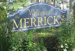
Merrick is a hamlet and census-designated place (CDP) in the Town of Hempstead in Nassau County, New York, United States. As of the 2010 census, the CDP population was 22,097.[1] The name Merrick is taken from the word Meroke (oyster bed), the name of the ancestral homeland of the Algonquian tribe formerly indigenous to the area. It is served by the Merrick station on the Long Island Rail Road on the Babylon line.
Merrick, New York | |
|---|---|
Hamlet and census-designated place | |
 | |
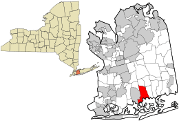
 Location in Nassau County and the state of New York. | |
 Merrick, New York Location within the state of New York | |
| Coordinates: 40°39′34″N 73°33′13″W | |
| Country | United States |
| State | New York |
| County | Nassau |
| Area | |
| • Total | 5.2 sq mi (13.5 km2) |
| • Land | 4.2 sq mi (10.9 km2) |
| • Water | 1.0 sq mi (2.6 km2) |
| Elevation | 13 ft (4 m) |
| Population (2010) | |
| • Total | 22,097 |
| • Density | 4,200/sq mi (1,600/km2) |
| Demonym(s) | Merokian |
| Time zone | UTC-5 (Eastern (EST)) |
| • Summer (DST) | UTC-4 (EDT) |
| ZIP code | 11566 |
| Area code(s) | 516 |
| FIPS code | 36-46668 |
| GNIS feature ID | 0956989 |
Geography

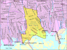
According to the United States Census Bureau, the CDP has a total area of 5.2 square miles (13 km2), of which 4.2 square miles (11 km2) is land and 1.0 square mile (2.6 km2), or 19.27%, is water.
Merrick has a climate that is bordering upon hot-summer humid continental (Dfa) and humid subtropical (Cfa.) The Cfa zone is found along Merrick's coast. The average monthly temperatures in the town centre range from 31.7 °F in January and 74.8 °F in July. The local hardiness zone is 7b.
Demographics
As of the census of 2000, there were 22,764 people, 7,524 households, and 6,478 families residing in the CDP. The population density was 5,423.3 per square mile (2,092.7/km2). There were 7,602 housing units at an average density of 1,811.1/sq mi (698.8/km2). The racial makeup of the CDP was 95.18% White, 0.56% African American, 0.10% Native American, 2.24% Asian, 0.01% Pacific Islander, 0.94% from other races, and 0.98% from two or more races.
There were 7,524 households, out of which 42.9% had children under the age of 18 living with them, 76.0% were married couples living together, 7.6% had a female householder with no husband present, and 13.9% were non-families. 11.6% of all households were made up of individuals, and 6.6% had someone living alone who was 65 years of age or older. The average household size was 3.02 and the average family size was 3.27.
In the CDP, the population was spread out, with 27.5% under the age of 18, 5.4% from 18 to 24, 27.7% from 25 to 44, 26.7% from 45 to 64, and 12.7% who were 65 years of age or older. The median age was 40 years. For every 100 females, there were 93.2 males. For every 100 females age 18 and over, there were 90.8 males.
The median income for a household in the CDP was $93,132, and the median income for a family was $99,589.[2] (According to a 2007 estimate, these values had risen to $111,536 and $122,319 respectively.) Males had a median income of $79,607 versus $41,618 for females. The per capita income for the CDP was $26,334. About 2.0% of families and 2.8% of the population were below the poverty line, including 3.6% of those under age 18 and 2.2% of those age 65 or over.
Schools
The schools in Merrick and North Merrick make up the Merrick and North Merrick School Districts, as well as part of the Bellmore–Merrick Central High School District (BMCHSD). Below are the schools, their grade levels, and the towns that attend them.
| School | Grades | Town(s) That Go To School |
|---|---|---|
| Birch School | K–6 | Merrick |
| Roland A. Chatterton School | K–6 | Merrick |
| Norman J. Levy Lakeside School | K–6 | Merrick |
| Park Avenue School | K–6 | North Merrick |
| Camp Avenue School | K–6 | North Merrick |
| Harold D. Fayette School | K–6 | North Merrick |
| Old Mill Road School | K–6 | North Merrick |
| Merrick Avenue Middle School* | 7–8 | North Merrick, Merrick |
| Grand Avenue Middle School* | 7–8 | Bellmore |
| Sanford H. Calhoun High School* | 9–12 | North Merrick, Merrick |
| John F. Kennedy High School* | 9–12 | Merrick & Bellmore, South of Merrick Road |
| Wellington C. Mepham High School* | 9–12 | Bellmore |
- An asterisk means that the school is part of the Bellmore Merrick Central High School District. All other schools are in the district of town that attends them.
Notable people
- Craig Allen, Fox News weatherman
- Roone Arledge, former president of ABC Sports/News
- Justin Beck, guitarist in the band Glassjaw
- Melissa Howard Beck, cast member, The Real World New Orleans
- Ed Begley, actor
- Ed Begley, Jr., actor
- Janet Billig, record executive, Broadway producer
- Brian Bloom, actor
- Schuyler V. Cammann, professor of Oriental Studies, University of Pennsylvania
- Vinnie Caruana, lead singer of I Am the Avalanche and The Movielife
- Leonard Chang, author
- CheapyD, owner of Cheap Ass Gamer
- Ben Cohen, co-founder of Ben and Jerry's ice cream[3]
- Doreen Cronin, children's author
- Doug Ellin, writer/creator of Entourage
- Amy Fisher, the "Long Island Lolita"
- Frank Frazetta, fantasy artist
- Paul George Feinman, associate judge of the New York Court of Appeals
- Bill Freiberger, Emmy-nominated writer/producer of The Simpsons, The PJs
- Debbie Gibson, singer
- Jerry Greenfield, co-founder of Ben and Jerry's ice cream[3]
- Ryan Hunter, lead vocalist of the band Envy On The Coast
- Danny Kopec, international chess master
- Michael Kors, fashion designer
- Paul R. Krugman, 2008 Nobel Prize in Economics, New York Times columnist, professor and scholar
- Scott Lipsky (born 1981), tennis player
- Elliot S. Maggin, writer
- Michael Markowitz, writer/producer of Horrible Bosses, Becker and Duckman
- Romeo Muller, screenplay writer of Santa Claus Is Coming to Town, Frosty the Snowman, Little Drummer Boy
- The Lohan residence including Lindsay, Michael Jr., Ali, Dakota and Dina Lohan
- Constantinos Philippou, mixed martial artist
- Mario Puzo, author of the novel The Godfather (later adapted to film by Francis Ford Coppola)
- Steve Rifkind, hip hop entrepreneur
- Robbie Rosen, singer, contestant on season 10 of American Idol
- Noah Rubin (born 1996), tennis player
- Zack Ryder, WWE professional wrestler, former WWE Intercontinental Champion and WWE United States Champion, WWE Tag Team Champion
- Sha Na Na (George and Rob Leonard), Woodstock festival, Grease album rock group
- Kevin Shinick, actor/writer/director, notably Robot Chicken and was the host of the PBS game show Where in Time is Carmen Sandiego?
- James Siegel, author of Derailed, adapted to a film starring Jennifer Aniston and Clive Owen
- Lee Tepper, co-founder of MerchDirect with Glassjaw's Justin Beck
- Marc Slutsky, Musician
- Bruce Sussman, Songwriter
Films
- 2002 – Blue Vinyl (dir. Daniel B. Gold and Judith Helfand)
- 2010 – Mildred Pierce (starring Kate Winslet, directed by Todd Haynes)
- 2019 – Abigail (dir. Max Hechtman and Christonikos Tsalikis)
See also
References
- "Merrick CDP, New York". American FactFinder. Archived from the original on February 14, 2020. Retrieved October 4, 2011.
- "Profile of Selected Economic Characteristics: 2000". American FactFinder. Archived from the original on February 13, 2020. Retrieved October 4, 2011.
- Dreifus, Claudia. "PASSING THE SCOOP; BEN & JERRY". Retrieved April 3, 2018.
External links
| Wikivoyage has a travel guide for Merrick. |

_(9418804364).jpg)
_(29235540794).jpg)
