Melgar Province
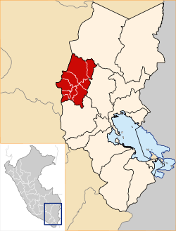
Melgar Province is a province of the Puno Region in Peru.[1] The capital of the province is the city of Ayaviri.
Melgar | |
|---|---|
.jpg) Mountains at the La Raya pass | |
 Coat of arms | |
 Location of Melgar in the Puno Region | |
| Country | Peru |
| Region | Puno |
| Capital | Ayaviri |
| Government | |
| • Mayor | Esteban Alvarez Ccasa |
| Area | |
| • Total | 6,446.85 km2 (2,489.14 sq mi) |
| Elevation | 3,907 m (12,818 ft) |
| Population | |
| • Total | 67,138 |
| • Density | 10/km2 (27/sq mi) |
| UBIGEO | 2108 |
| Website | www.ayaviriweb.com |
Geography
The Willkanuta range and the La Raya range traverse the province. Some of the highest mountains of the province are listed below:[2]
- Achuqallani
- Aqu Punta
- Chachakumani
- Anqasi
- Chimpulla
- Chunta
- Chuwani
- Ch'iyar Jaqhi (Puno-Cusco)
- Ch'iyar Jaqhi (Melgar)
- Ch'iyar Salla
- Ch'ulla Rinri
- Ch'uxña Quta
- Hatun Ichhuna Kunka
- Hatun Sallika
- Hatun Yuraq Qaqa
- Hatunk'uchu
- Inka Kancha
- Jalanta
- Janq'u Q'awa
- Jarupata
- Lluxisa
- Kimsa Kunka
- Kuntur Saya
- Kunka
- Kuntur Pata
- Kuntur Sayana
- Kunturwasa
- Khunurana (Carabaya-Melgar)
- Khunurana (Melgar)
- Llallawi
- Mamaniri
- Maych'a Sinqa
- Minas Tira
- Misapata
- Misti Urqu
- Muru Muruni
- Muru Q'atawi
- Ñiq'i Quta
- Pichaqani
- Pirwani
- P'isaqani
- Puka Ch'uwaña
- Puka Parina
- Puka Urqu
- P'iya Qhuyani
- Qillqa
- Qillwa Quta
- Qinamari
- Quchak'uchu
- Qullpa Qaqa
- Qullpa Tira
- Qhuna Tira
- Q'atawi
- Q'illu Qaqa
- Sach'apata
- Salla Muqu
- Salla Tira
- Salla Wanqani
- Sampu
- Sapan Warmi
- Silla Qhata
- Silluta
- Sura Punta
- Surapata
- Taruja Marka
- T'aqañawi
- T'uqra
- Wamanlipani
- Wanq'uni
- Warmi Uma
- Waylla Wit'u
- Wila Pata
- Wilaquta
- Willkanuta
- Willu Punchu
- Wiqu
- Wisa Wisa (Lampa-Melgar)
- Wisa Wisa (Melgar)
- Wit'u Uma
- Yana Khuchilla
- Yana Qaqa
- Yana Salla
- Yanaqucha (Carabaya-Melgar)
- Yanaqucha (Melgar)
- Yaritani
- Yuraq Qaqa
- Yuraq Q'asa (near Chullupata)
- Yuraq Q'asa (near Pumanuta)
Political division
The province measures 6,446.85 square kilometres (2,489.14 sq mi) and is divided into nine districts:
| District | Mayor | Capital | Ubigeo |
|---|---|---|---|
| Antauta | Ignacio Edgar Chura Mendoza | Antauta | 210802 |
| Ayaviri | Bernardo Natividad Meza Alvarez | Ayaviri | 210801 |
| Cupi | Yudel Rene Mamani Cervantes | Cupi | 210803 |
| Llalli | Leon Vilca Gamarra | Llalli | 210804 |
| Macari | Simon Amador Mamani Chañi | Macari | 210805 |
| Nuñoa | Atilio Rodo Huaman Tapara | Nuñoa | 210806 |
| Orurillo | Juan Rene Quispe Chunga | Orurillo | 210807 |
| Santa Rosa | Filiberto Tacca Navarro | Santa Rosa | 210808 |
| Umachiri | N | Umachiri | 210809 |
Ethnic groups
The people in the province are mainly indigenous citizens of Quechua descent. Quechua is the language which the majority of the population (70.54%) learnt to speak in childhood, 29.09% of the residents started speaking using the Spanish language and 0.23% using Aymara (2007 Peru Census).[3]
gollark: ~np
gollark: ~delete 3
gollark: ~q
gollark: ~queu
gollark: ~skip
See also
External links
- (in Spanish) Official website
References
- (in Spanish) Instituto Nacional de Estadística e Informática. Banco de Información Digital Archived 2008-04-23 at the Wayback Machine, Retrieved January 2, 2008
- escale.minedu.gob.pe - UGEL map of the Melgar Province (Puno Region)
- inei.gob.pe Archived 2013-01-27 at the Wayback Machine INEI, Peru, Censos Nacionales 2007
This article is issued from Wikipedia. The text is licensed under Creative Commons - Attribution - Sharealike. Additional terms may apply for the media files.