Huancané Province
Huancané Province (from Aymara Wanqani ![]()
Huancané Wanqani | |
|---|---|
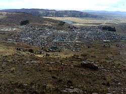
 Huancané | |
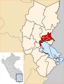
 Location of Huancané Wanqani in the Puno Region | |
| Country | Peru |
| Region | Puno |
| Founded | September 19, 1827 |
| Capital | Huancané |
| Government | |
| • Mayor | Alex Gómez Pacoricona |
| Area | |
| • Total | 2,805.85 km2 (1,083.34 sq mi) |
| Elevation | 3,809 m (12,497 ft) |
| Population | |
| • Total | 74,542 |
| • Density | 27/km2 (69/sq mi) |
| UBIGEO | 2106 |
| Website | www.mphuancane.pe.nu |
Geography
One of the highest peaks of the district is Khawayuni at approximately 5,000 m (16,000 ft). Other mountains are listed below:[2]
- Anta Waralla
- Apachita
- Aqu Aqu
- Awqani
- Chunta Salla
- Chuwallani
- Chhuqa Llusk'a
- Ch'illiw Tira
- Ch'iyar K'uchu
- Ch'iyar Salla
- Jach'a Waylla
- Janq'u Qala
- Janq'u Qullu
- Jaqhi Jaqhini
- Jichu Qullu
- Juri Quta
- Kiswar Qullu
- K'ank'a Qullu
- Laram Sillani
- Lawa Lawani
- Maych'ani
- Limani
- Llallawi
- Mullu Marka
- Muru Qullu
- Pichaqani
- Pirwa Pirwani
- Pukara
- Pura Purani
- P'unqu Pata
- Qillwani
- Qhilla Qhillani
- Salla Kunka
- Sillani
- Turini
- T'urpu Kunka
- Upa Uqhu
- Wallatiri
- Wara Qullu
- Waraq Tira
- Wari Muña
- Wayllani
- Wiluyu
- Wisk'achani
Political division
The province measures 2,805.85 square kilometres (1,083.34 sq mi) and is divided into eight districts:
| District | Mayor | Capital | Ubigeo |
|---|---|---|---|
| Cojata | Hector Exaltacion Montesinos Aliaga | Cojata | 210602 |
| Huancané | Alex Gomez Pacoricona | Huancané | 210601 |
| Huatasani | Miguel Condori Condori | Huatasani | 210603 |
| Inchupalla | Juan Sucasaire Aquise | Inchupalla | 210604 |
| Pusi | Elias Quiroga Gutierrez | Pusi | 210605 |
| Rosaspata | Clodoaldo Poma Castro | Rosaspata | 210606 |
| Taraco | Efrain Vilca Callata | Taraco | 210607 |
| Vilque Chico | Hilario Ramos Salluca | Vilque Chico | 210608 |
Ethnic groups
The people in the province are mainly indigenous citizens of Aymara and Quechua descent. Aymara is the language which the majority of the population (53.26%) learnt to speak in childhood, 30.82% of the residents started speaking using the Quechua language and 15.70% using Spanish (2007 Peru Census).[3]
gollark: A great inspiration for osmarksISA™-2029!
gollark: It's been sent to the GTech™ Apiaristics Division™.
gollark: The Event.
gollark: Alternatively, just hook up an antenna to it and clock your thing based on whatever signals happen to be drifting around (you may need an amplifier).
gollark: Just replace your crystal oscillator with you switching a switch *really* fast.
See also
References
- (in Spanish) Instituto Nacional de Estadística e Informática. Banco de Información Digital Archived 2008-04-23 at the Wayback Machine, Retrieved January 2, 2008
- escale.minedu.gob.pe/ UGEL map Huancané Province (Puno Region)
- inei.gob.pe Archived 2013-01-27 at the Wayback Machine INEI, Peru, Censos Nacionales 2007
This article is issued from Wikipedia. The text is licensed under Creative Commons - Attribution - Sharealike. Additional terms may apply for the media files.