Azángaro Province
Azángaro Province is a province of the Puno Region in Peru.[1]
Azángaro | |
|---|---|
 Flag  Coat of arms | |
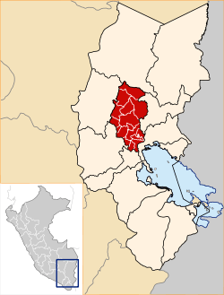 Location of Azángaro in the Puno Region | |
| Country | Peru |
| Region | Puno |
| Capital | Azángaro |
| Government | |
| • Mayor | Ruben Pachari Inofuente |
| Area | |
| • Total | 4,970.01 km2 (1,918.93 sq mi) |
| Elevation | 3,850 m (12,630 ft) |
| Population | |
| • Total | 136.523 |
| • Density | 0.027/km2 (0.071/sq mi) |
| UBIGEO | 2102 |
| Website | www |
Languages
According to the 2007 census, Quechua was spoken by 81.0% of the population as their first language, while 18.4% spoke Spanish, 0.3% spoke Aymara, 0.0% spoke Asháninka, 0.1% spoke other indigenous languages and 0.0% spoke foreign languages.
Political division
The province measures 4,970.01 square kilometres (1,918.93 sq mi) and is divided into fifteen districts:
| District | Mayor | Capital | Ubigeo |
|---|---|---|---|
| Achaya | Pepe Romulo Condori Carlosviza | Achaya | 210202 |
| Arapa | Cesar Gilberto Torres Rosello | Arapa | 210203 |
| Asillo | Jose Ludgardo Torres Sucari | Asillo | 210204 |
| Azángaro | Flavio Jesus Mamani Hancco | Azángaro | 210201 |
| Caminaca | Cesar Augusto Huaman Suero | Caminaca | 210205 |
| Chupa | Clemente Idelionso Lopez Chipana | Chupa | 210206 |
| José Domingo Choquehuanca | Ponsiano Mamani Ccala | Estación de Pucara | 210207 |
| Muñani | Leonidas Endara Mamani | Muñani | 210208 |
| Potoni | Seferino Quispe Turpo | Potoni | 210209 |
| Saman | Luis Mamani Gonzales | Saman | 210210 |
| San Antón | Adrian Joel Quispe Alata | San Antón | 210211 |
| San José | Enrique Eron Alarcon Huahuacondori | San José | 210212 |
| San Juan de Salinas | Edgar Inofuente Cari | San Juan de Salinas | 210213 |
| Santiago de Pupuja | Jaime Roger Yapo Arapa | Santiago de Pupuja | 210214 |
| Tirapata | Marino Pumaleque Mango | Tirapata | 210215 |
Geography
Some of the highest mountains of the province are listed below:[2]
- Allqamarini
- Chiwanani
- Chuqi Muruq'u
- Ch'iyar Jaqhi
- Ch'iyara Apachita
- Hatun Jayuni
- Hatun Qurini
- Ichhu Muruq'u
- Muru Sinqa
- Pacha Punta
- Pukara
- Pukarani
- Pupusani
- P'isaqani
- P'ukru Pata
- Qiñwani
- Quri Kunka
- Q'atawi Qullu
- Sullukuta
- Sura Pata
- Surupana
- Taruja Pincha
- Uqi Apachita
- Usqulluni
- Waylla Tira
- Wayna Putus
- Wila Kunka
- Wila Sirka
- Wila Susuya
- Wila Tuqu
- Willkanuta
- Wiluyu
- Yuraq Apachita
gollark: Why shouldn't it be?
gollark: I think that would work, if you were insane, which you would be.
gollark: SMFW the type system is more expressive than the language.
gollark: The templates are TC IIRC.
gollark: It doesn't explicitly specify the size of any types IIRC, so it's not memory-limited. Well, the spec isn't, obviously no implementation is tC.
See also
References
- (in Spanish) Instituto Nacional de Estadística e Informática. Banco de Información Digital Archived April 23, 2008, at the Wayback Machine, Retrieved November 8, 2007
- escale.minedu.gob.pe - UGEL map of the Azángaro Province (Puno Region)
External links
- (in Spanish) Official website
- Municipalidad Provincial de Azangaro
| |
|---|---|
This article is issued from Wikipedia. The text is licensed under Creative Commons - Attribution - Sharealike. Additional terms may apply for the media files.