High Wavy Mountains
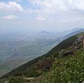
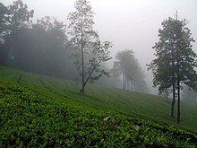
Meghamalai (Tamil: மேகமலை), commonly known as the High Wavy Mountains, is a mountain range located in the Western Ghats in the Theni district near Kumily, Kerala. It is dotted with cardamom plantations and tea estates. The mountain range is 1,500 metres above sea level, and it is rich in flora and fauna. The area, now mostly planted with tea plants, includes cloudlands, high wavys, venniar, and the manalar estates belonging to the Woodbriar Group. Access is largely restricted and includes largely untouched remnants of evergreen forest.[1]
Megamalai Wildlife Sanctuary
For a long time, there has been a pending proposal with the Tamil Nadu Forest Department to establish the Megamalai Wildlife Sanctuary on 600 km2 of forest in the division. The suggested priority tasks in the sanctuary include: the control of poaching, the use of pesticides for the elimination of ganja (Cannabis sativa) and the cultivation as well as scientific management of watersheds. The Megamalai Wildlife Sanctuary can be an excellent buffer to the Periyar Tiger Reserve and Grizzled Squirrel Wildlife Sanctuary which can immensely strengthen the conservation in the southern Western Ghats – the range of hills south of the Palakkad Gap.[2]
Wildlife found on the High Wavy Mountains include Oriental honey buzzard, great pied hornbill, Indian brown mongoose, Jerdon's palm civet, white-bellied short-wing, black-naped monarch, pied thrush, gaur, tiger, leopard, Asian elephant, mouse deer, Ghatixalus asterops, Raorchestes beddomii, Raorchestes ponmudi, Nyctibatrachus sp., Ramanella triangularis, Ramanella montana, Calotes grandisquamis, Hemidactylus anamallensis, Salea anamallayana, Kaestlea travancorica, Kaestlea laterimaculata, Uropeltis madurensis, Uropeltis liura, Calliophis nigrescens, large-scaled pit viper and the enigmatic Hutton's pit viper.
When the high wavys group of estates were managed by Hindustan Unilever, the company started a non-profit orgainization called the Megamalai Wildlife and Environment Association. It worked with the forest department to protect the endangered species and safeguard the forest and its creatures; it did so by putting up signs promoting the preservation of nature and animals along the Ghat road of Meghamalai. Unfortunately, most of these signs were destroyed in an expansion project that took place on the Ghat road. The forest department has put new signs to replace the damaged ones.[3]
Flora
According to the experts the last extensive study of flora in the biodiversity-rich, Meghamalai have been conducted in the early 1980s. Since then, no comprehensive research has been done on the vegetation. Vegetation ranges from scrub forests at the foothills, ubiquitous expanses of tea and coffee estates, to spice (pepper, helllcardamom, cinnamon) plantations and finally to the dense evergreen forests at the top.[4]
Fauna
Meghamalai forest area hosts a variety of birds, mammals, reptiles and butterflies. Resident and migratory elephants are also common. There are hundreds of identified species:
Wildlife of Vellimalai
- Spotted deer
- Spotted dove
- Barking deer
- Sambar deer
- Mousedeer
- Grizzled giant squirrel
- Indian flying fox
- Indian giant squirrel
- Indian giant flying squirrel
- Pied thrush
- Black bulbul
- RedEye
- Black baza
- White-bellied woodpecker
- White-bellied drongo
- Drongo cuckoo
- Black-naped oriole
- Black-naped monarch
- Black-naped hare
- Tiger
- Dhole
- Great pied hornbill
- Malabar pied hornbill
- Oriental honey-buzzard
- Dusky palm squirrel
- Bison
Tourist attractions

Tea estates and dams
The Highwavys provide a view of the entire mountain range of Varusanadu Hills. There are large private tea, spices, and coffee plantations all around, notably the Highwavys Group of Estates. Ananda Plantations, Ponsiva Plantations, and Fieldmede Estate, are also some of the other small plantations in Meghamalai. An artificial lake makes plenty of scope for leisurely walks. Kardana Coffee Estate is situated in the High Wavy Mountains at 9°42′N 77°24′E.[5]
Six dams on the hill and originating place of Suruli Theertham (Suruli falls near Cumbum town) are popular attractions for tourists. From the Manalar dam, one can view the deep Cumbum Valley and the villages of Theni district. The Department of Tourism has planned to introduce a boat or ferry service to enable tourists to access the area.[6]
Vellimalai
The Vellimalai (Silver Mountain, 1,650 m) area is the heart of Meghamalai. Silver-lined clouds seem to rest gently on green hilltops; nestled in this region is the place where the river Vaigai originates. This place offers an opportunity to see wild animals aesthetically and scientifically managed tea gardens.
Falls
Meghamalai Falls (Suruli Falls) is on the Suruli River originating in the Meghamalai Hills. Water flows down 58 meters through the twin falls. There are frequent visits by elephants, spotted deer, gaur, and other wild animals at dawn and dusk. Forest Department officials have plans to assist tourists in viewing these wild animals.
Encroachment threat
Massive encroachments in the reserved forests of almost all divisions in the district have been posing a threat to the eco-system of the Megamalai hills. Of the total 806.86 km2, about 400.77 km2 were degraded forest area. A total of 292.81 km2 falls under dense forest areas, of which only 22.43 km2 was tree bearing. About 220 out of 430 km2 of the Gandamanur forest range under the Madurai Forest Division had encroached in the past four decades. Large areas of Ulloothu Kavu, Anjaraipuli, Elamalaipoodu, Arasaradi, Bommarasapuram, and neighboring villages were also encroached. With an increase in population and their demands, vast stretches of land were either degraded or converted into uni-crop areas, causing damage to the environment. The people settled in the hill tracts were solely dependent on the forests for livelihood. Conservation of natural forest in any form will help preserve biodiversity.[7]
Access
The Meghamalai mountain range can be approached two ways—from Theni via Chinnamanur, or Andipatti via Kandamanayakkanur. Both can be accessed by road from Madurai and Dindigul. Theni is 76 km from Madurai. The road from the turnoff near Chinnamanur before Iravangalar was under the responsibility of the Woodbriar group; due to lack of maintenance, the government has started to maintain it. Only forest lodges and panchayath rest houses are available at the hilltop. Day-trippers may stay in hotels in Theni, Chinnamanur and Andipatti. The distance from Madurai is 130 km.
The website for Mehamalai has a warning against travelling there in June and July.[8] [9][10]
Gallery
 Meghamalai Mountains
 Meghamalai
 Cloudy Mountain
 Manalaru Dam
 View of Cumbam Valley
 Wildlife
 Asian elephant in megamalai tea estate
 Bisons at Meghamalai
 Forest
 Meghamalai
 Murugan Temple on the foot hill
 Upper Manalar Estate
 The Highwavys of Theni district
 High Wavys Dam
 Meghamalai Coffee Plant
References
- ANGUS F. HUTTON AND PATRICK DAVID (September–December 2008). "NOTE ON A COLLECTION OF SNAKES FROM SOUTH INDIA, WITH EMPHASIS ON THE SNAKE FAUNA OF THE MEGHAMALAI HILLS (HIGHWAVYS MOUNTAINS)" (PDF). Journal of the Bombay Natural History Society. Bombay Natural History Society. 105 (3): 299–316. Archived from the original (PDF) on 27 March 2018.
- National Wildlife Data Center (2006) Wildlife Institute of India, retrieved 3/31/2007 List of Proposed Wildlife Sanctuaries in India
- https://www.unilever.com/Images/es_2003_tea-a-popular-beverage_tcm244-409725_en.pdf.
- Vandhana, M. (10 September 2014). "Lot to be explored of Meghamalai flora". The Hindu. ISSN 0971-751X. Retrieved 3 June 2020.
- N. Singaravelan and G. Marimuthu (10 May 2003). "Discovery of a cave as the day roost of a rarest fruit bat Latidens salimalii" (PDF). Current Science. 84 (9).
- Highwavys to become a major tourism spot
- Encroachments a threat to Megamalai hills sanctuary plan
- June July Safety Warning!, megamalai.com, retrieved 21 January 2015
- https://www.thehindu.com/news/cities/chennai/over-100-trees-felled-to-widen-road-in-meghamalai/article8362906.ece
- http://environmentclearance.nic.in/writereaddata/FormB/TOR/Brief_Summary/18_Jul_2016_121332030AUF9CFS8TotalDetails.pdf.
External links
| Wikimedia Commons has media related to Meghamalai. |
- Megamalai Tamil Nadu, Meghamalai tourist places
- The Magical Megamalai
- Meghamalai - A Walk in the Clouds
- Holiday at the High Wavys
- The Hidden Paradise
- Magamalai Tourism
- Wild Elephants Video
- Wild Elephants Video-2
- Wild Elephants Video-3
- Meghamalai Video
- Meghamalai water falls Video
- Malabar Giant Squirrel Video

