Main road 4 (Hungary)
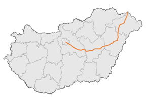
The Main road 4 is a west–east direction First class main road across the Alföld region of Hungary, that connects Budapest to the biggest eastern Hungarian cities: Szolnok, Debrecen, Nyíregyháza towards the border of Ukrainian, facilitating access from the capital city of Hungary to the Ukrainian border. The road is 352 kilometres (219 mi) long[1], this is the longest Hungarian main road. Most of the traffic was taken over by the M4 expressway until Püspökladány.
| |
|---|---|
| 4 főút | |
 | |
| Route information | |
| Part of | |
| Length | 352.0 km (218.7 mi) |
| Major junctions | |
| From | Budapest |
| To | Záhony |
| Location | |
| Counties | Pest, Jász-Nagykun-Szolnok, Hajdú-Bihar, Szabolcs-Szatmár-Bereg |
| Major cities | Budapest, Vecsés, Üllő, Monor, Pilis, Albertirsa, Cegléd, Abony, Szolnok, Törökszentmiklós, Fegyvernek, Kenderes, Kisújszállás, Karcag, Püspökladány, Kaba, Hajdúszoboszló, Debrecen, Hajdúhadház, Téglás, Újfehértó, Nyíregyháza, Ajak, Kisvárda, Záhony |
| Highway system | |
_Otszogletu_zold_tabla.svg.png)
The road, as well as all other main roads in Hungary, is managed and maintained by Magyar Közút, state owned company.
Sources
- Magyarország, autóatlasz 1:200.000, Honvédelmi Minisztérium Térképészeti Kht., ISBN 978-963-257-087-7.
gollark: Deploying undifferentiable functions...
gollark: I found this graph of heavpoot.
gollark: Hmm, so arbitrary SVGs?!
gollark: Also, fun idea: add a command to provide arbitrary striped lime emojis on demand.
gollark: What's the difference?
See also
External links
| Wikimedia Commons has media related to Route 4 (Hungary). |
- Hungarian Public Road Non-Profit Ltd. (Magyar Közút Nonprofit Zrt.)
- National Infrastructure Developer Ltd.
| Motorways | |
|---|---|
| Expressways | |
| 1st Class Roads | |
| 2nd Class Roads |
|
Planned | |
This article is issued from Wikipedia. The text is licensed under Creative Commons - Attribution - Sharealike. Additional terms may apply for the media files.