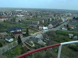
Záhony
Záhony (Ukrainian: Загонь) is a town in Szabolcs-Szatmár-Bereg county, in the Northern Great Plain region of eastern Hungary.
Záhony | |
|---|---|
 | |
 Flag  Coat of arms | |
 Záhony Location of Záhony | |
| Coordinates: 48.417°N 22.183°E | |
| Country | |
| County | Szabolcs-Szatmár-Bereg |
| Area | |
| • Total | 6.87 km2 (2.65 sq mi) |
| Population (2015)[1] | |
| • Total | 4,156 |
| • Density | 600/km2 (1,600/sq mi) |
| Time zone | UTC+1 (CET) |
| • Summer (DST) | UTC+2 (CEST) |
| Postal code | 4625 |
| Area code(s) | 45 |
| Website | www |
It covers an area of 6.97 km2 (3 sq mi) and has a population of 4675 people (2005). It is near the Ukrainian border (at Chop and Solomonovo) and was part of Ung county before Trianon Treaty. Road and railway border crossings into Ukraine are located here. The Ukrainian town across the border is Chop.
International relations
Twin towns – Sister cities
Záhony is twinned with:

Gallery
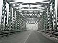 The Tysa bridge at the Chop-Záhony checkpoint (view from the Ukrainian side).
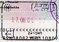 Passport stamp from Záhony.
gollark: You realise that we know exactly who all your "spies" are?
gollark: They aren't mindless, they have onboard control AIs.
gollark: Wow, that is a GREAT source of data on everyone's life ever in scenarios you haven't experienced‽
gollark: You can't even make apinators work within 18 orders of magnitude of the effectiveness of GTech™ ones!
gollark: Based on what?
References
- Gazetteer of Hungary, 1 January 2015. Hungarian Central Statistical Office.


| Wikimedia Commons has media related to Záhony. |
This article is issued from Wikipedia. The text is licensed under Creative Commons - Attribution - Sharealike. Additional terms may apply for the media files.