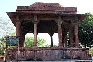
Mahaban
Mahaban is a town and a nagar panchayat in Mathura district in the Indian state of Uttar Pradesh. Poet Raskhan's tomb is situated here.

Mahaban | |
|---|---|
 Mahaban Location in Uttar Pradesh, India  Mahaban Mahaban (India) | |
| Coordinates: 27.43°N 77.75°E | |
| Country | |
| State | Uttar Pradesh |
| District | Mathura |
| Elevation | 176 m (577 ft) |
| Population (2001) | |
| • Total | 8,608 |
| Languages | |
| • Official | Hindi |
| • Native | Braj Bhasha dialect |
| Time zone | UTC+5:30 (IST) |
History
Mahaban is said to have been found by Nanda, the foster father and paternal uncle of Lord Krishna before Krishna's birth , it was then ruled by Yadavas. Mahavan is situated about six miles east of Mathura. It is also called Brihadvan, because it is the largest of all the forests. In fact this forest has three names: Mahavan, Gokul and Brihadvan.
Legends suggest that Krishna spent his childhood at Mahaban.[1] Secred temples of Mathuranath, Palace of Nanda (The Assi-Khamba) and Raman Reti (The play ground of Krishna) still exist here.
Mahaban was sacked by Mahmud of Ghazani in 1018[2] and thereafter by Iltutamish, Shahjahan and Ahmed Shah Abdali.
Geography
Mahaban is located at 27.43°N 77.75°E.[3] It has an average elevation of 176 metres (577 feet).
Demographics
As of 2001 India census,[4] Mahaban has a population of 8,608. Males constitute 54% of the population and females 46%. Mahaban has an average literacy rate of 39%, lower than the national average of 59.5%: male literacy is 51%, and female literacy is 25%. In Mahaban, 20% of the population is under 6 years of age.
References
- Yatra 2 Yatra. Yatra2Yatra. 2009. pp. 67–. GGKEY:LTN9ZD2D2Y0. Retrieved 26 May 2018.
- Dilip K. Chakrabarty (18 October 2010). The Geopolitical Orbits of Ancient India: The Geographical Frames of the Ancient Indian Dynasties. OUP India. pp. 170–. ISBN 978-0-19-908832-4. Retrieved 26 May 2018.
- Falling Rain Genomics, Inc - Mahaban
- "Census of India 2001: Data from the 2001 Census, including cities, villages and towns (Provisional)". Census Commission of India. Archived from the original on 16 June 2004. Retrieved 1 November 2008.