Maconcourt
Maconcourt is a commune in the Vosges department in Grand Est in northeastern France.
Maconcourt | |
|---|---|
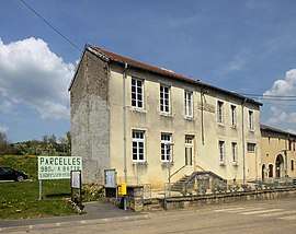 The town hall and school in Maconcourt | |
.svg.png) Coat of arms | |
Location of Maconcourt 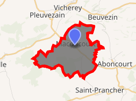
| |
 Maconcourt  Maconcourt | |
| Coordinates: 48°21′59″N 5°56′29″E | |
| Country | France |
| Region | Grand Est |
| Department | Vosges |
| Arrondissement | Neufchâteau |
| Canton | Mirecourt |
| Intercommunality | CC l'Ouest Vosgien |
| Government | |
| • Mayor (2001–2008–2014) | Christian Laprévotte |
| Area 1 | 4.90 km2 (1.89 sq mi) |
| Population (2017-01-01)[1] | 75 |
| • Density | 15/km2 (40/sq mi) |
| Time zone | UTC+01:00 (CET) |
| • Summer (DST) | UTC+02:00 (CEST) |
| INSEE/Postal code | 88278 /88170 |
| Elevation | 318–455 m (1,043–1,493 ft) (avg. 340 m or 1,120 ft) |
| 1 French Land Register data, which excludes lakes, ponds, glaciers > 1 km2 (0.386 sq mi or 247 acres) and river estuaries. | |
Inhabitants are known as Maconcurtiens.
Geography
Maconcourt is a rural village that retains many traditional features. It is positioned on the northern edge of the department, adjacent to the Meurthe-et-Moselle department, some forty-five kilometres (twenty-nine miles) to the northwest of Épinal and fifty kilometres to the south-southwest of Nancy in the Upper Santois district. The Autoroute A31 runs south-north some six kilometres (four miles) to the west of the village, although in order to access this autoroute it is necessary to drive further, to Houécourt.
gollark: Isn't homomorphic encryption hilariously slow?
gollark: Yes.
gollark: You forgot antiemarkness and epicbot and heavpoot and ! ! ! heavpoot and one of the generic rust advocates.
gollark: --magic py ```pythonraise Exception("BEEËS")```
gollark: --exec ```pythonraise Exception("BEEËS")```
See also
References
- "Populations légales 2017". INSEE. Retrieved 6 January 2020.
| Wikimedia Commons has media related to Maconcourt (Vosges). |
| Authority control |
|
|---|
This article is issued from Wikipedia. The text is licensed under Creative Commons - Attribution - Sharealike. Additional terms may apply for the media files.