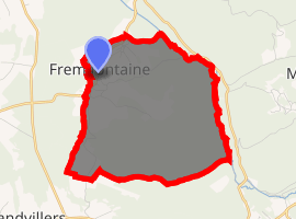
Fremifontaine
Fremifontaine is a commune in the Vosges department in Grand Est in northeastern France.
Fremifontaine | |
|---|---|
_%C3%A9glise.jpg) The church in Fremifontaine | |
.svg.png) Coat of arms | |
Location of Fremifontaine 
| |
 Fremifontaine  Fremifontaine | |
| Coordinates: 48°16′16″N 6°41′08″E | |
| Country | France |
| Region | Grand Est |
| Department | Vosges |
| Arrondissement | Épinal |
| Canton | Bruyères |
| Intercommunality | CC Bruyères - Vallons des Vosges |
| Government | |
| • Mayor (2008–2014) | Etienne Pourcher |
| Area 1 | 9.56 km2 (3.69 sq mi) |
| Population (2017-01-01)[1] | 469 |
| • Density | 49/km2 (130/sq mi) |
| Time zone | UTC+01:00 (CET) |
| • Summer (DST) | UTC+02:00 (CEST) |
| INSEE/Postal code | 88184 /88600 |
| Elevation | 329–469 m (1,079–1,539 ft) (avg. 339 m or 1,112 ft) |
| 1 French Land Register data, which excludes lakes, ponds, glaciers > 1 km2 (0.386 sq mi or 247 acres) and river estuaries. | |
Geography
The river Mortagne forms all of the commune's northeastern border.
gollark: Currencies CAN have different value to each other.
gollark: It's worth more than e.g. Japanese yen.
gollark: Doesn't matter.
gollark: Dog (insect).
gollark: Suuuure.
See also
References
- "Populations légales 2017". INSEE. Retrieved 6 January 2020.
| Wikimedia Commons has media related to Fremifontaine. |
This article is issued from Wikipedia. The text is licensed under Creative Commons - Attribution - Sharealike. Additional terms may apply for the media files.