Les Poulières
Les Poulières is a commune in the Vosges department in Grand Est in northeastern France.
Les Poulières | |
|---|---|
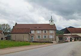 The town hall in Les Poulières | |
Location of Les Poulières 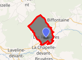
| |
 Les Poulières  Les Poulières | |
| Coordinates: 48°11′54″N 6°47′30″E | |
| Country | France |
| Region | Grand Est |
| Department | Vosges |
| Arrondissement | Saint-Dié-des-Vosges |
| Canton | Bruyères |
| Intercommunality | CA Saint-Dié-des-Vosges |
| Government | |
| • Mayor (2008–2014) | Sébastien Fritz |
| Area 1 | 2.98 km2 (1.15 sq mi) |
| Population (2017-01-01)[1] | 241 |
| • Density | 81/km2 (210/sq mi) |
| Time zone | UTC+01:00 (CET) |
| • Summer (DST) | UTC+02:00 (CEST) |
| INSEE/Postal code | 88356 /88660 |
| Elevation | 451–663 m (1,480–2,175 ft) (avg. 456 m or 1,496 ft) |
| 1 French Land Register data, which excludes lakes, ponds, glaciers > 1 km2 (0.386 sq mi or 247 acres) and river estuaries. | |
Inhabitants are called Polérois.
Geography
The commune is positioned between Épinal to the west and Saint-Dié to the north-east, in the valley of the Neuné, a tributary of the Vologne River. Neighbouring communes are Biffontaine and La Chapelle-devant-Bruyères. Les Poulières is at the confluence of several roads, but roads here are small and twisting, thanks to the topography, on the western fringes of the Vosges Mountains.
gollark: They can play people's selected theme music, moderately discomfiting whispers, bee noises, that sort of thing.
gollark: That would be stupid. They're tied into the facilitywide audio systems.
gollark: ++remind 10h link shortener thebcryoapiforosmz, and check T2
gollark: Average guess score weighted by guess difficulty in each relevant round.
gollark: <@319753218592866315> Metric idea!
See also
References
- "Populations légales 2017". INSEE. Retrieved 6 January 2020.
| Wikimedia Commons has media related to Les Poulières. |
This article is issued from Wikipedia. The text is licensed under Creative Commons - Attribution - Sharealike. Additional terms may apply for the media files.