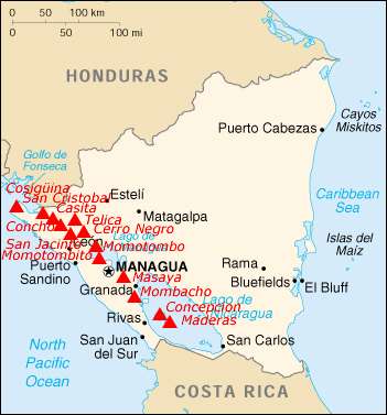
List of volcanoes in Nicaragua
Volcanoes
| Name | Elevation | Location | Last eruption | |
|---|---|---|---|---|
| meters | feet | Coordinates | ||
| Apoyeque | 518 | 1699 | 12.242°N 86.342°W | 50 BC |
| Ciguatepe | 603 | 1978 | 12.53°N 86.142°W | Holocene |
| Cerro Negro | 728 | 2388 | 12.506°N 86.702°W | 1999 |
| Concepción | 1700 | 5577 | 11.538°N 85.622°W | 2009 |
| Cosigüina | 872 | 2861 | 12.98°N 87.57°W | 1859 |
| Estelí | 899 | 2949 | 13.17°N 86.40°W | Holocene |
| Granada | 300 | 984 | 11.92°N 85.98°W | 10,000 BC |
| Lajas | 926 | 3038 | 12.30°N 85.73°W | Holocene |
| Las Pilas | 1088 | 3570 | 12.495°N 86.688°W | 1954 |
| Maderas | 1394 | 4573 | 11.446°N 85.515°W | Holocene |
| Masaya | 635 | 2083 | 11.984°N 86.161°W | continuing |
| Mombacho | 1344 | 4409 | 11.862°N 85.968°W | 1570 |
| Momotombo | 1297 | 4255 | 12.422°N 86.540°W | 2015 |
| Nejapa-Miraflores | 360 | 1181 | 12.12°N 86.32°W | Holocene |
| Rota | 832 | 2730 | 12.55°N 86.75°W | Holocene |
| San Cristóbal | 1745 | 5725 | 12.702°N 87.004°W | 2012 |
| Telica | 1061 | 3481 | 12.602°N 86.845°W | 2015 |
| Azul | 201 | 659 | 12.53°N 83.87°W | Holocene |
| Zapatera | 629 | 2064 | 11.73°N 85.82°W | Holocene |
gollark: <@!452148088136531979> Minecraft is a sandbox game.
gollark: Ah, "Lignum".
gollark: Oh no. The quarry turtles have gone rogue now I'm not connected.
gollark: You're just muons.
gollark: I can do that in about 30 seconds.
See also
References
- Siebert L, Simkin T (2002–present). Volcanoes of the World: an Illustrated Catalog of Holocene Volcanoes and their Eruptions. Smithsonian Institution, Global Volcanism Program Digital Information Series, GVP-3 (http://www.volcano.si.edu).
This article is issued from Wikipedia. The text is licensed under Creative Commons - Attribution - Sharealike. Additional terms may apply for the media files.
