List of volcanoes in Iceland
This list of volcanoes in Iceland includes 31[1] active and extinct volcanic mountains, of which 18 have erupted since human settlement of Iceland began circa 900 CE.
List
| Name | Elevation (m) | Elevation (ft) | Coordinates | Last eruption | VEI | Notes |
|---|---|---|---|---|---|---|
| Askja | 1516 | 4974 | 65.03°N 16.75°W | 1961 | 5 | |
| Bárðarbunga | 2005 | 6515 | 64.64°N 17.56°W | 2015 | ||
| Brennisteinsfjöll | 626 | 2054 | 63.92°N 21.83°W | 1341 (± 1 year) | 2 | |
| Eldfell | 279 | 915 | 63.43°N 20.25°W | 1973 | 3 | Vestmannaeyjar island of Heimaey |
| Eldgjá | ca 800 | ca 2625 | 64.24°N 18.37°W | 934 | 6 | This volcano is a vent of Katla |
| Esjufjöll | 1760 | 5774 | 64.27°N 16.65°W | 1927 | ||
| Eyjafjallajökull | 1666 | 5466 | 63.63°N 19.62°W | 2010 | 4 | |
| Fremrinámur | 939 | 3081 | 65.43°N 16.65°W | 800 BC (± 300 years) | ||
| Grensdalur | 497 | 1631 | 64.02°N 21.17°W | dormant | Active during Pleistocene | |
| Grímsnes | 214 | 702 | 64.03°N 20.87°W | ~3500 BC | 3 | |
| Grímsvötn | 1725 | 5659 | 64.42°N 17.33°W | 2011 | 4 | |
| Hekla | 1491 | 4892 | 63.98°N 19.70°W | 2000 | 3 | |
| Helgafell | 227 | 745 | 63.43°N 20.26°W | 3950 BCE (± 300 years) | Vestmannaeyjar island of Heimaey | |
| Hengill | 803 | 2634 | 64.18°N 21.33°W | 90 AD (± 100 years) | 2 | |
| Herðubreið | 1682 | 5518 | 65.18°N 16.34°W | dormant | Active during Pleistocene | |
| Hofsjökull | 1782 | 5846 | 64.85°N 19.53°W | dormant | Active during Holocene | |
| Holuhraun | 778 | 2553 | 64.84°N 16.83°W | 2015 | part of the Bárðarbunga fissure system | |
| Hrómundartindur | 540 | 1772 | 64.07°N 21.20°W | 10,000 BC | ||
| Hverfjall | 420 | 1378 | 65.36°N 16.53°W | ~500 BC | part of the Krafla fissure system | |
| Hveravellir | 1360 | 4462 | 64.75°N 19.98°W | 950 AD ± 50 years | 6 | central volcano of the eastern Langjökull system |
| Jólnir | 70* | 230* | 63.30°N 20.63°W | 1966 | This vent of Surtsey has since eroded to below sea level | |
| Katla | 1512 | 4961 | 63.63°N 19.05°W | 1918 | ||
| Kerlingarfjöll | 1488 | 4882 | 64.63°N 19.32°W | dormant | Active during Holocene | |
| Kolbeinsey Ridge | 5 | 16 | 66.67°N 18.50°W | 1755[2] | ||
| Kollóttadyngja | 1177 | 3825 | 65.22°N 16.55°W | unknown | ||
| Krafla | 650 | 2133 | 65.73°N 16.78°W | 1984 | 4 | |
| Krýsuvík | 379 | 1243 | 63.93°N 22.10°W | probably ~1340 | 2 | |
| Krakatindur | 300 | 984 | 63.55°N 19.30°W | unknown | ||
| Kverkfjöll | 1920 | 6299 | 64.65°N 16.72°W | 1968 | 1 | |
| Laki | 1725 | 5606 | 64.06°N 18.22°W | 1783-84 | 6 | part of Grímsvötn fissure system |
| Loki-Fögrufjöll | 1570 | 5151 | 64.48°N 17.80°W | 1910 | ||
| Ljósufjöll | 988 | 3241 | 64.87°N 22.23°W | 960 AD (± 10 years) | 3 | |
| Lýsuhóll | 540+ | 1772+ | 64.87°N 23.25°W | dormant | Active during Holocene | |
| Öræfajökull | 2119 | 6952 | 64.00°N 16.65°W | 1727 | 5 | |
| Prestahnúkur | 1386 | 4504 | 64.60°N 20.60°W | 7550 BC (± 500 years) | central volcano of western Langjökull system | |
| Reykjanes | 230 | 755 | 63.88°N 22.50°W | 1879 | ||
| Reykjaneshryggur | -80 | -262 | 63.67°N 23.33°W | 1970 | ||
| Snæfellsjökull | 1448 | 4751 | 64.80°N 23.78°W | 200 AD (± 150 years) | 2 | |
| Surtsey | 174 | 571 | 63.30°N 20.62°W | 1963 | in the Vestmannaeyjar islands | |
| Theistareykjarbunga | 564 | 1850 | 65.88°N 16.83°W | 750 BC (± 100 years) | ||
| Thordarhyrna | 64.12°N 17.0°W | 1910 | 4 | |||
| Þórólfsfell | 574 | 1883 | 63.72°N 19.67°W | unknown | ||
| Thrihnukagigur | 550 | 1804 | 63.99°N 21.7°W | 2 BC | ||
| Tindfjallajökull | 1463 | 4800 | 63.78°N 19.57°W | dormant | Active during Holocene | |
| Torfajökull | 1259 | 4131 | 63.92°N 19.17°W | 1477 | 3 | |
| Trölladyngja | 1468 | 4816 | 64.89°N 17.25°W | ~2980 BC | ||
| Tungnafellsjökull | 1535 | 5036 | 64.73°N 17.92°W | dormant | Active during Holocene | |
| Vatnafjöll | 1235 | 4052 | 63.92°N 19.67°W | 750 AD (± 1000 years) |
Volcanic zones and systems

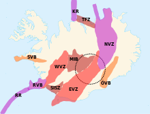
Iceland has four major volcanic zones surrounding an hypothetic hotspot: the Reykjanes zone (RVZ), subdivided in the Reykjanes Ridge (RR) (the Mid-Atlantic Ridge South of Iceland) and the Reykjanes Volcanic Belt (RVB) (on the main island); the West Volcanic Zone (WVZ); the East Volcanic Zone (EVZ) (extended to the Westman Islands, South of the main island); and the North Volcanic Zone (NVZ). The Mid-Iceland Belt (MIB) connects them across central Iceland.
In the Iceland's East Volcanic Zone (EVZ), the central volcanoes, Vonarskarð and Hágöngur belong to the same volcanic system; this also applies to Bárðarbunga and Hamarinn, and to Grímsvötn and Þórðarhyrna.[3]
North of Iceland, the Mid-Atlantic Ridge is called Kolbeinsey Ridge (KR) and connected to the North Volcanic Zone via the Tjörnes Fracture Zone (TFZ). Also the South Iceland Seismic Zone (SISZ) is another fracture zone, that connects the East and West Volcanic Zones. Both fracture zones also include their own volcanic systems, smaller than those in the Mid-Iceland Belt.
Beside the hotspot area fragmenting the Mid-Atlantic Ridge, there are also two intraplate volcanic belts: Öræfajökull (ÖVB) on the Eurasian plate, and Snæfellsnes (SVB) on the North American plate.[4][5] It is proposed that the east-west line going from the Grímsvötn volcano in the Mid-Iceland Belt (MIB) to the Snæfellsnes volcanic belt (SVB) shows the movement of the North American Plate over the Iceland hotspot.[6]
| # | Volcanic zone | Volcanic system | Name of central volcano of the volcanic system |
|---|---|---|---|
| 1 | RVZ | Reykjanes/Svartsengi | Gunnuhver |
| 2 | RVZ | Krýsuvík | Trölladyngja (Reykjanesskagi) |
| 3 | RVZ | Brennisteinsfjöll | void |
| 4 | WVZ | Hengill | Hengill |
| 5 | WVZ | Hrómundartindur | Hrómundartindur |
| 6 | WVZ | Grensdalur | void |
| 7 | WVZ | Grímsnes | Seyðishólar |
| 8 | WVZ | Geysir | Laugarfjall |
| 9 | WVZ | Western Langjökull | Prestahnúkur |
| 10 | WVZ | Eastern Langjökull | Hveravellir |
| 11 | MIB | Hofsjökull | Hofsjökull |
| 12 | MIB | Kerlingarfjöll | Snækollur |
| 13 | MIB | Tungnafellsjökull | Tungnafellsjökull/Hágöngur |
| 14 | EVZ | Vestmannaeyjar (Westman Islands) | void |
| 15 | EVZ | Eyjafjallajökull | Eyjafjallajökull |
| 16 | EVZ | Katla | Katla |
| 17 | EVZ | Tindfjallajökull | Tindfjallajökull |
| 18 | EVZ | Hekla-Vatnafjöll | Hekla |
| 19 | EVZ | Torfajökull | Torfajökull |
| 20 | EVZ | Bárðarbunga-Veiðivötn | Bárðarbunga/Hamarinn |
| 21 | EVZ | Grímsvötn | Grímsvötn/Thórdarhyrna |
| # | EVZ | (Central volcanoes, as well) | (Vonarskard/Hágöngur)[3] |
| 22 | NVZ | Kverkfjöll | Austari Kverkfjöll |
| 23 | NVZ | Askja | Askja |
| 24 | NVZ | Fremrinámur | void |
| 25 | NVZ | Krafla | Krafla |
| 26 | NVZ | Þeistareykir | Þeistareykjabunga |
| 27 | ÖVB | Öræfajökull | Öræfajökull |
| 28 | ÖVB | Esjufjöll | Snæhetta |
| 29 | ÖVB | Snæfell | Snæfell |
| 30 | SVB | Ljósufjöll | void |
| 31 | SVB | Lýsuskarð | Helgrindur |
| 32 | SVB | Snæfellsjökull | Snæfellsjökull |
See also
- Lists of volcanoes
- Volcanology of Iceland
References
- Siebert L, Simkin T (2002–present). Volcanoes of the World: an Illustrated Catalog of Holocene Volcanoes and their Eruptions. Smithsonian Institution, Global Volcanism Program Digital Information Series, GVP-3 (http://www.volcano.si.edu).
- Thor Thordarsson, Armann Hoskuldsson: Classic Geology in Europe 3. Iceland. Harpenden, Terra, 2002
- https://www.pbs.org/wgbh/nova/earth/doomsday-volcanoes.html
- http://futurevolc.vedur.is/#
- "Global Volcanism Program | Kolbeinsey Ridge". Archived from the original on 2018-09-20. Retrieved 2017-12-13.
- T. Gudmundsson; Thórdís Högnadóttir (January 2007). "Volcanic systems and calderas in the Vatnajökull region, central Iceland: Constraints on crustal structure from gravity data". Journal of Geodynamics. 43 (1): 153–169. Bibcode:2007JGeo...43..153G. doi:10.1016/j.jog.2006.09.015.
- T. Thordarson; G. Larsen (January 2007). "Volcanism in Iceland in historical time: volcano types, eruption styles and eruptive history". Journal of Geodynamics. 43 (1): 118–152. Bibcode:2007JGeo...43..118T. doi:10.1016/j.jog.2006.09.005.
- H. Jóhannesson; K. Sæmundsson (1998). Geologic Map of Iceland, 1:500,000. Bedrock Geology. Reykjavík: Icelandic Institute of Natural History and Iceland Geodetic Survey.
- W. Jason Morgan; Jason Phipps Morgan. Plate velocities in hotspot reference frame: electronic supplement (PDF). p. 111. Retrieved 2010-04-23.
