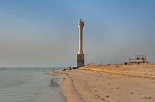
List of lighthouses in Qatar
Lighthouses
| Name | Image | Year built | Location & coordinates | Class of Light [2] | Focal height[2] | NGA number[2] | Admiralty number[2] | Range nml[2] |
|---|---|---|---|---|---|---|---|---|
| Halat Umm Al Khayfan Lighthouse | n/a | offshore Doha 25°09′06.0″N 51°57′36.0″E (NGA) | Fl (2) W 20s. | 13 metres (43 ft) | 29912 | D7382 | 18 | |
| Jazirat Halul Lighthouse |  | n/a | Halul Island 25°40′25.2″N 52°24′32.9″E | Fl WR 12s. | 67 metres (220 ft) | 29816 | D7378 | white: 19 red: 9 |
| Lightfloat Doha | n/a | offshore Doha 25°16′24.0″N 51°45′06.0″E (NGA) | Mo (D) W 12s. | 6 metres (20 ft) | 29892 | D7389 | 8 | |
| Ra's al Matbakh Lighthouse | Image | n/a | Ras Matbakh 25°40′49.3″N 51°34′48.8″E | Fl WR 5s. | 17 metres (56 ft) | 29812 | D7393 | white: 21 red: 18 |
| Ra's Umm Hasah Lighthouse |  | n/a | Al Ghariyah 26°06′03.0″N 51°21′38.5″E | V Q (3) W 5s. | 12 metres (39 ft) | 29794 | D7394.5 | 10 |
gollark: So some sort of concept-mapping thing with the graph as main interface?
gollark: Interesting...
gollark: The graph would just be a representation of the structure of your notes.
gollark: How would *that* make sense?
gollark: Minoteaur™ may in fact integrate prometheus metrics tracking certain interesting variables in order to something something graphs.
See also
- Lists of lighthouses and lightvessels
References
- Qatar The Lighthouse Directory. University of North Carolina at Chapel Hill. Retrieved 13 October 2016
- List of Lights, Pub. 112: Western Pacific and Indian Oceans Including the Persian Gulf and Red Sea (PDF). List of Lights. United States National Geospatial-Intelligence Agency. Retrieved 13 October 2016
External links
- Rowlett, Russ. "The Lighthouse Directory". University of North Carolina at Chapel Hill.
This article is issued from Wikipedia. The text is licensed under Creative Commons - Attribution - Sharealike. Additional terms may apply for the media files.
_-_cropped.jpg)