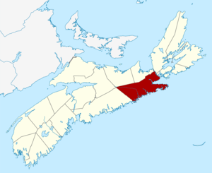
List of historic places in Guysborough County, Nova Scotia
List of historic places
| Name | Address | Coordinates | IDF | IDP | IDM | Image | |
|---|---|---|---|---|---|---|---|
| 16 Cameron Road | 16 Cameron Road, Sherbrooke, NS | 45°08′34″N 61°59′12″W | 14741 |  | |||
| Campbell & MacKeen Law Office | 146 Main St., Guysborough, NS | 45°23′38″N 61°30′01″W | 14881 | | |||
| Canso Islands National Historic Site of Canada | School Street, Canso, NS | 45°20′48″N 60°58′15″W | 14304 | | |||
| Christ Church Anglican | 144 Church Street, Guysborough, NS | 45°23′21″N 61°29′56″W | 14932 | | |||
| Commercial Cable Building | 10 Front Street, Hazel Hill, NS | 45°19′42″N 61°01′40″W | 5744 | 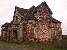 More images | |||
| Government of Canada Building | 15 Main Street, Sherbrooke, NS | 45°08′31″N 61°59′00″W | 10973 | | |||
| Grassy Island Fort National Historic Site of Canada | , Canso, NS | 45°20′15″N 60°58′19″W | 11666 | 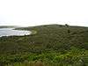 | |||
| Harbour House | 163 Green Street, Guysborough, NS | 45°23′21″N 61°29′47″W | 3407 | | |||
| Heritage Goldenville Society | 199 Goldenville Road, Goldenville, NS | 45°07′27″N 62°00′32″W | 15156 | | |||
| Holy Trinity Anglican Church | 16733 Route 316, Country Harbour Mines, NS | 45°15′47″N 61°50′54″W | 14935 | | |||
| Isaac's Harbour United Baptist Church | 382 Isaac's Harbour Rd, Isaac's Harbour, NS | 45°10′49″N 61°39′38″W | 14841 | | |||
| Jost House | 62 Main Street, Guysborough, NS | 45°23′28″N 61°29′52″W | 13539 | | |||
| Jost's Wharf Building | , Guysborough, NS | 45°23′30″N 61°29′53″W | 14897 | | |||
| Kirk Memorial United Church | 1007 Glenelg Church Road, Aspen, NS | 45°16′51″N 62°04′36″W | 15161 | | |||
| Light Tower | Country Island, off Seal Harbour, Guysborough County, NS | 45°05′59″N 61°32′32″W | 15161 | | |||
| Queensport Lighthouse | Rook Island, Queensport, NS | 45°20′53″N 61°16′18″W | 2922 20773 |
| |||
| Lighttower | Isaac's Harbour Road, Isaacs Harbour, NS | 45°09′52″N 61°39′17″W | 4805 | | |||
| New Chester Community Club | New Chester Road, New Chester, NS | 45°01′29″N 62°12′37″W | 15141 | | |||
| Old Guysborough Court House Museum | 283 Church Street, Guysborough, NS | 45°23′21″N 61°29′55″W | 3053 | | |||
| Laurel Rebekah Lodge | , Goldboro, NS | 45°10′49″N 61°39′02″W | 14901 | | |||
| The Reynolds Property | 5525 Hwy 16, Queensport, NS | 45°14′28″N 61°21′10″W | 14930 | | |||
| St. Thomas Church | 4029 South River Rd, Salmon River Lake, NS | 45°21′33″N 61°43′13″W | 14934 | | |||
| St. Vincent de Paul Church | 5475 Route 16, Queensport, NS | 45°20′24″N 61°16′10″W | 14933 | | |||
| Stormont Masonic Lodge #96 | 530 Isaac's Harbour Rd, Isaac's Harbour, NS | 45°10′29″N 61°39′19″W | 14898 | | |||
| Stormont Union Church | 15324 Route 316, Stormont, NS | 45°13′50″N 61°45′00″W | 14936 | |
gollark: It's permitted by GTech™ GRFC™ 11084G.
gollark: Now, if it can't find some humans to fix the site, the next step is to scan for exploitable vulnerabilities in related components to get access to the code and work out how to display the site.
gollark: It still existed.
gollark: There are also various techniques it could use to find the likely operators/owners of the site and convince them to repair whatever the issue is.
gollark: If DNS resolution was successful then the browser knows the site's server's approximate location. So in case of connectivity issues it could dispatch a maintenance drone.
See also
| Wikimedia Commons has media related to Cultural heritage monuments in Nova Scotia. |
- List of historic places in Nova Scotia
- List of National Historic Sites of Canada in Nova Scotia
- Heritage Property Act (Nova Scotia)
This article is issued from Wikipedia. The text is licensed under Creative Commons - Attribution - Sharealike. Additional terms may apply for the media files.