List of Pennsylvania state historical markers in Forest County
This is a list of the Pennsylvania state historical markers in Forest County.
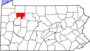
Location of Forest County in Pennsylvania
This is intended to be a complete list of the official state historical markers placed in Forest County, Pennsylvania by the Pennsylvania Historical and Museum Commission (PHMC). The locations of the historical markers, as well as the latitude and longitude coordinates as provided by the PHMC's database, are included below when available. There are 11 historical markers located in Forest County.[1]
Historical markers
| Marker title | Image | Date dedicated | Location | Marker type | Topics |
|---|---|---|---|---|---|
| Damascus | July 29, 1947 | US 62 at Tionesta 41.507679°N 79.451993°W |
Roadside | Cities & Towns | |
| Forest County | August 21, 1982 | County Courthouse, Elm Street (US 62), Tionesta 41.49665°N 79.45623°W |
City | Environment, Government & Politics, Government & Politics 19th Century | |
| Goschgoschink | July 29, 1947 | US 62, south of PA 127, East Hickory 41.56805°N 79.40352°W |
Roadside | Cities & Towns, Early Settlement, Native American (Lenape) | |
| Hickory Town | July 29, 1947 | US 62 & Little Hickory Road, East Hickory 41.55905°N 79.41885°W |
Roadside | Cities & Towns, Early Settlement, Native American, Paths & Trails | |
| Holeman Ferry | August 5, 1954 | US 62, 3 miles southwest of Tionesta (MISSING) |
Roadside | Business & Industry, Transportation | |
| Howard Zahniser | August 13, 2001 | US 62 just north of Tionesta 41.51855°N 79.44265°W |
Roadside | Environment, Government & Politics (20th century) | |
| Indian Paths | July 29, 1947 | US 62, 2.3 miles south of East Hickory 41.54583°N 79.43158°W |
Roadside | Native American | |
| Lawunakhannek | July 29, 1947 | US 62, .2 mile north of East Hickory 41.58643°N 79.40387°W |
Roadside | Early Settlement, Native American (Lenape), Religion (Moravian mission) | |
| Pigeon | June 3, 1948 | PA 66 & Pigeon Lane, 6 miles northeast of Marienville 41.52535°N 79.05625°W |
Roadside | Cities & Towns, Environment, Native American | |
| Refugee Towns | July 29, 1947 | US 62, 1.5 miles south of Tionesta 41.476784°N 79.47156°W |
Roadside | Early Settlement, Native American | |
| Refugee Towns | July 29, 1947 | US 62, .5 mile north of East Hickory 41.58652°N 79.403847°W |
Roadside | Early Settlement, Native American |
See also
References
- "PHMC Historical Markers Search" (Searchable database). Pennsylvania Historical and Museum Commission. Commonwealth of Pennsylvania. Retrieved 2010-07-19.
External links
Municipalities and communities of Forest County, Pennsylvania, United States | ||
|---|---|---|
| Borough | | |
| Townships | ||
| CDP | ||
| Unincorporated communities | ||
| Footnotes | ‡This populated place also has portions in an adjacent county or counties | |

This article is issued from Wikipedia. The text is licensed under Creative Commons - Attribution - Sharealike. Additional terms may apply for the media files.