Les Etchemins Regional County Municipality
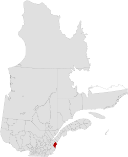
Les Etchemins is a regional county municipality in the Chaudière-Appalaches region of eastern Quebec, Canada. It is named for the Etchemin River which finds its source in the region, as well as Etchemin Lake. Lac-Etchemin is the seat of the RCM. Les Etchemins can be found on the Maine border, southeast of Quebec City.
Les Etchemins | |
|---|---|
 | |
| Coordinates: 46°24′N 70°21′W[1] | |
| Country | |
| Province | |
| Region | Chaudière-Appalaches |
| Effective | January 1, 1982 |
| County seat | Lac-Etchemin |
| Government | |
| • Type | Prefecture |
| • Prefect | Hector Provençal |
| Area | |
| • Total | 1,819.40 km2 (702.47 sq mi) |
| • Land | 1,810.05 km2 (698.86 sq mi) |
| Population (2016)[3] | |
| • Total | 16,536 |
| • Density | 9.1/km2 (24/sq mi) |
| • Change 2011-2016 | |
| • Dwellings | 8,764 |
| Time zone | UTC−5 (EST) |
| • Summer (DST) | UTC−4 (EDT) |
| Area code(s) | 418 and 581 |
| Website | www |
Subdivisions
There are 13 subdivisions within the RCM:[2]
|
|
Transportation
Access Routes
Highways and numbered routes that run through the municipality, including external routes that start or finish at the county border:[4]
gollark: Also Crying Ghasts?
gollark: https://www.curseforge.com/minecraft/mc-mods/silents-gems MAY be interesting.
gollark: Mayhaps the misty world mod.
gollark: Perhaps Cyclic.
gollark: <@160279332454006795> opinionate.
References
- Reference number 141072 of the Commission de toponymie du Québec (in French)
- Geographic code 280 in the official Répertoire des municipalités (in French)
- "Census Profile, 2016 Census: Les Etchemins, Municipalité régionale de comté [Census division], Quebec". Statistics Canada. Retrieved November 28, 2019.
- Official Transport Quebec Road Map
External links
Adjacent Counties & Equivalent Territories | |
|---|---|
| Regional county municipalities and equivalent territories | |
|---|---|
| Municipalities |
|
This article is issued from Wikipedia. The text is licensed under Creative Commons - Attribution - Sharealike. Additional terms may apply for the media files.