La Nouvelle-Beauce Regional County Municipality
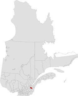
La Nouvelle-Beauce (New Beauce) is a regional county municipality in the Chaudière-Appalaches region in southeastern Quebec, Canada, south of the Saint Lawrence River. It is located south of Lévis, along the Chaudière River.
La Nouvelle-Beauce | |
|---|---|
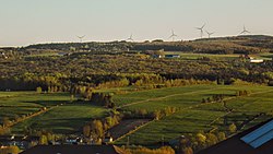
 Nouvelle-Beauce landscape in Sainte-Marie and Saint-Elzéar. | |
 | |
| Coordinates: 46°27′N 71°02′W[1] | |
| Country | |
| Province | |
| Region | Chaudière-Appalaches |
| Effective | January 1, 1982 |
| County seat | Sainte-Marie |
| Government | |
| • Type | Prefecture |
| • Prefect | Richard Lehoux |
| Area | |
| • Total | 911.80 km2 (352.05 sq mi) |
| • Land | 905.58 km2 (349.65 sq mi) |
| Population (2016)[3] | |
| • Total | 36,785 |
| • Density | 40.6/km2 (105/sq mi) |
| • Change 2011-2016 | |
| • Dwellings | 15,501 |
| Time zone | UTC−5 (EST) |
| • Summer (DST) | UTC−4 (EDT) |
| Area code(s) | 418 and 581 |
| Website | www |
| [4] | |
Established in 1982 as a successor to Dorchester County, La Nouvelle-Beauce is made of 11 municipalities and is mainly French-speaking (99.2% French-speaking in 2006) and rural. Sainte-Marie, the county seat, is the most populous municipality.
The name of La Nouvelle-Beauce reminds the one given to the area along the Chaudière River by the French authorities until the end of the French Regime in North America.
Subdivisions
There are 11 subdivisions within the RCM:[2]
|
|
|
Transportation
Access Routes
Highways and numbered routes that run through the municipality, including external routes that start or finish at the county border:[5]
References
- Reference number 141089 of the Commission de toponymie du Québec (in French)
- Geographic code 260 in the official Répertoire des municipalités (in French)
- "Census Profile, 2016 Census: La Nouvelle-Beauce, Municipalité régionale de comté [Census division], Quebec". Statistics Canada. Retrieved November 28, 2019.
- "(Code 2426) Census Profile". 2011 census. Statistics Canada. 2012.
- Official Transport Quebec Road Map