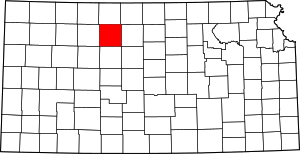
Laton, Kansas
Laton (initially Eagle Creek) was a small settlement in Corning Township, Rooks County, Kansas, United States.
Laton, Kansas | |
|---|---|
| Coordinates: 39°17′08″N 99°04′36″W | |
| Country | United States |
| State | Kansas |
| County | Rooks |
| Elevation | 2,073 ft (632 m) |
| Time zone | UTC-6 (Central (CST)) |
| • Summer (DST) | UTC-5 (CDT) |
| GNIS feature ID | 484596[1] |
History
Eagle Creek was issued a post office in 1878. In 1884 the post office name was changed to Laton before being discontinued in 1904.[2] In addition to the post office Laton had a school, store, cream station, garage, blacksmith shop, and telephone office.[3] The population in 1910 was 30.[4]
The Midland Trail (Red Line Highway) passed thru Laton on its initial route in 1914. The creation of U.S Route 40N (US-24) to the north and K-18 highway to the south by-passed Laton.[5]
Laton School District R-5, Rooks County, Kansas was disorganized in 1962.[6] There is nothing left of Laton.
gollark: Ender modems can send and receive at arbitrary distances.
gollark: You can use a regular wireless modem on the other end.
gollark: Honestly, I would have liked it more if the unlimited range modems were big structures of some sort so routing actually existed.
gollark: Yes, wireless modems can only go some amount of blocks depending on their height and the weather.
gollark: The only real advantage it has is routing, and ender modems obsoleted that (which I'm kind of sad about).
References
- "US Board on Geographic Names". United States Geological Survey. 1978-10-13. Retrieved 2017-12-05.
- "Kansas Post Offices, 1828-1961". Kansas Historical Society. Retrieved 2017-12-05.
- "Rooks County Historical Society", Plainville Times, 3 July 1975, p.4
- Blackmar, Frank Wilson (1912). Kansas: A Cyclopedia of State History, Volume 2, Chicago: Standard Publishing Company, p. 107
- "THE RED LINE", Plainville Times, 16 July 1914, p.1
- "TO WHOM IT MAY CONCERN", The Natoma Luray Independent, 19 July 1962, p.5
This article is issued from Wikipedia. The text is licensed under Creative Commons - Attribution - Sharealike. Additional terms may apply for the media files.


