Lat Bua Luang District
Lat Bua Luang (Thai: ลาดบัวหลวง, pronounced [lâːt būa̯ lǔa̯ŋ]) is a district (amphoe) in the southern part of Ayutthaya Province, central Thailand.
Lat Bua Luang ลาดบัวหลวง | |
|---|---|
 Khlong Phraya Banlue | |
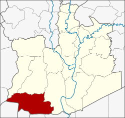 District location in Ayutthaya Province | |
| Coordinates: 14°9′57″N 100°18′27″E | |
| Country | Thailand |
| Province | Ayutthaya |
| Seat | Lat Bua Luang |
| Tambon | 7 |
| Area | |
| • Total | 199.9 km2 (77.2 sq mi) |
| Population (2000) | |
| • Total | 36,186 |
| • Density | 181.0/km2 (469/sq mi) |
| Time zone | UTC+7 (ICT) |
| Postal code | 13230 |
| Geocode | 1410 |
History
Tambon Lat Bua Luang was separated from Amphoe Bang Sai and officially upgraded to a district in 1947.
Geography
Neighboring districts are (from the north clockwise) Bang Sai (บางซ้าย), Sena, and Bang Sai (บางไทร) of Ayutthaya Province, Sam Khok and Lat Lum Kaeo of Pathum Thani Province, Sai Noi of Nonthaburi Province, Bang Len of Nakhon Pathom Province, and Song Phi Nong of Suphanburi Province.
Administration
The district is divided into seven sub-districts (tambon). Lat Bua Luang is a township (thesaban tambon) covering parts of the tambon Lat Bua Luang.
| 1. | Lat Bua Luang | ลาดบัวหลวง | |
| 2. | Lakchai | หลักชัย | |
| 3. | Sam Mueang | สามเมือง | |
| 4. | Phraya Banlue | พระยาบันลือ | |
| 5. | Singhanat | สิงหนาท | |
| 6. | Khu Salot | คู้สลอด | |
| 7. | Khlong Phraya Banlue | คลองพระยาบันลือ |
gollark: Interestingly, your monitor cannot display a *worrying* quantity of cyans.
gollark: Solution: field programmable FPGA gate array.
gollark: If you make the counters/adders/register bigints it might still work.
gollark: Well, it makes humans entirely unable to distinguish violet and purple objects, which GTech™ has actually used for [REDACTED].
gollark: The image is not* somehow lacking half the spectrum and/or weirdly colored.
This article is issued from Wikipedia. The text is licensed under Creative Commons - Attribution - Sharealike. Additional terms may apply for the media files.