Phachi District
Phachi (Thai: ภาชี, pronounced [pʰāːt͡ɕʰīː]) is a district in the eastern part of Ayutthaya Province.
Phachi ภาชี | |
|---|---|
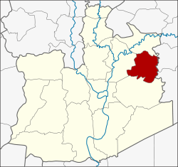 District location in Ayutthaya Province | |
| Coordinates: 14°26′57″N 100°43′42″E | |
| Country | Thailand |
| Province | Ayutthaya |
| Seat | Phachi |
| Tambon | 8 |
| Area | |
| • Total | 104.5 km2 (40.3 sq mi) |
| Population (2000) | |
| • Total | 30,481 |
| • Density | 291.7/km2 (755/sq mi) |
| Time zone | UTC+7 (ICT) |
| Postal code | 13140 |
| Geocode | 1409 |
History
The district was created in 1953, by separating it from Uthai District.
Phachi in Thai means 'divide' or 'junction', which refers to the railway junction between the northern and northeastern branches in the district.
Geography
Neighboring districts are (from the north clockwise) Tha Ruea of Ayutthaya Province; Nong Saeng and Nong Khae of Saraburi Province; and Uthai and Nakhon Luang of Ayutthaya.
Administration
The district is divided into eight sub-districts (tambon).
| 1. | Phachi | ภาชี | |
| 2. | Khok Muang | โคกม่วง | |
| 3. | Rasom | ระโสม | |
| 4. | Nong Nam Sai | หนองน้ำใส | |
| 5. | Don Ya Nang | ดอนหญ้านาง | |
| 6. | Phai Lom | ไผ่ล้อม | |
| 7. | Krachio | กระจิว | |
| 8. | Phra Kaeo | พระแก้ว |
gollark: You want help *being* murdered or muder*ing*?
gollark: A. Skynet is hosted on my server, not computer.B. It runs over a network.
gollark: You can just connect anything via skynet, no cable nonsense.
gollark: What does?
gollark: It just runs in the sky, if you happen to connect via satellite internet.
References
This article is issued from Wikipedia. The text is licensed under Creative Commons - Attribution - Sharealike. Additional terms may apply for the media files.