Lat Lum Kaeo District
Lat Lum Kaeo (Thai: ลาดหลุมแก้ว, pronounced [lâːt lǔm kɛ̂ːw]) is the westernmost district of Pathum Thani Province, central Thailand.
Lat Lum Kaeo ลาดหลุมแก้ว | |
|---|---|
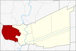 District location in Pathum Thani Province | |
| Coordinates: 14°2′14″N 100°24′17″E | |
| Country | Thailand |
| Province | Pathum Thani |
| Seat | Rahaeng |
| District established | 28 March 1916 |
| Area | |
| • Total | 183.12 km2 (70.70 sq mi) |
| Population (2017) | |
| • Total | 65,563 |
| • Density | 358.03/km2 (927.3/sq mi) |
| Time zone | UTC+7 (ICT) |
| Postal code | 12140 |
| Geocode | 1305 |
History
The district was established on 28 March 1916.[1]
Geography
Neighboring districts are (from the north clockwise): Lat Bua Luang of Ayutthaya Province; Sam Khok and Mueang Pathum Thani of Pathum Thani Province; and Pak Kret, Bang Bua Thong, and Sai Noi of Nonthaburi Province.
Administration
The district is divided into seven sub-districts (tambons), which are further subdivided into 67 villages (mubans). Rahaeng is a sub-district municipality (thesaban tambon) and covers part of tambon Rahaeng. Each of the tambons has a Tambon administrative organization (TAO).
| No. | Name | Thai | Villages | Pop.[2] |
|---|---|---|---|---|
| 1. | Rahaeng | ระแหง | 12 | 13,693 |
| 2. | Lat Lum Kaeo | ลาดหลุมแก้ว | 7 | 4,439 |
| 3. | Khu Bang Luang | คูบางหลวง | 12 | 7,934 |
| 4. | Khu Khwang | คูขวาง | 5 | 5,361 |
| 5. | Khlong Phra Udom | คลองพระอุดม | 13 | 5,464 |
| 6. | Bo Ngoen | บ่อเงิน | 7 | 4,320 |
| 7. | Na Mai | หน้าไม้ | 11 | 11,784 |
gollark: > We have detected that you are using AdBlock.> This is fine with me. I just like showing off with my website design.chaotic neutral.
gollark: Bad idea #12592: write programs for all the poem esolangs, and disseminate them on the internetwebs as if they are normal, if odd, poetry.
gollark: Bad idea #12591: modify random poetry until it does something interesting.
gollark: Bad idea #12950: feed random poetry into poem interpreters to see what happens.
gollark: Unless you consider y a vowel?
References
- ประกาศกระทรวงมหาดไทย เรื่อง ให้แบ่งเขตท้องที่ ในจังหวัดปทุมธานี (PDF). Royal Gazette (in Thai). 34 (0 ก): 5. 1917-04-01.
- "Population statistics 2008". Department of Provincial Administration. Archived from the original on 2010-02-22. Retrieved 2010-02-15.
External links
- amphoe.com (Thai)
|  | |
This article is issued from Wikipedia. The text is licensed under Creative Commons - Attribution - Sharealike. Additional terms may apply for the media files.