Kwun Tong station
Kwun Tong (Chinese: 觀塘; Cantonese Yale: Gūntòng) is a station on the MTR Kwun Tong line in Hong Kong. The station was opened in 1979 as the eastern terminus of the first phase of the MTR network, called the "Modified Initial System", until the Eastern Harbour Crossing to Quarry Bay opened in 1989. It is located in the Kwun Tong area, between Lam Tin and Ngau Tau Kok stations.
| MTR rapid transit station | ||||||||||||||||||||||||||||||||||||||||||||||||||||||||||||||||||||||||||||||||||||||||||||||||||
Platform 1 | ||||||||||||||||||||||||||||||||||||||||||||||||||||||||||||||||||||||||||||||||||||||||||||||||||
| Chinese name | ||||||||||||||||||||||||||||||||||||||||||||||||||||||||||||||||||||||||||||||||||||||||||||||||||
| Traditional Chinese | 觀塘 | |||||||||||||||||||||||||||||||||||||||||||||||||||||||||||||||||||||||||||||||||||||||||||||||||
| Simplified Chinese | 观塘 | |||||||||||||||||||||||||||||||||||||||||||||||||||||||||||||||||||||||||||||||||||||||||||||||||
| Jyutping | Gun1tong4 | |||||||||||||||||||||||||||||||||||||||||||||||||||||||||||||||||||||||||||||||||||||||||||||||||
| Hanyu Pinyin | Guāntáng | |||||||||||||||||||||||||||||||||||||||||||||||||||||||||||||||||||||||||||||||||||||||||||||||||
| ||||||||||||||||||||||||||||||||||||||||||||||||||||||||||||||||||||||||||||||||||||||||||||||||||
| General information | ||||||||||||||||||||||||||||||||||||||||||||||||||||||||||||||||||||||||||||||||||||||||||||||||||
| Location | Kwun Tong Road Interchange, Kwun Tong Kwun Tong District, Hong Kong | |||||||||||||||||||||||||||||||||||||||||||||||||||||||||||||||||||||||||||||||||||||||||||||||||
| Coordinates | 22°18′44″N 114°13′35″E | |||||||||||||||||||||||||||||||||||||||||||||||||||||||||||||||||||||||||||||||||||||||||||||||||
| Operated by | MTR Corporation | |||||||||||||||||||||||||||||||||||||||||||||||||||||||||||||||||||||||||||||||||||||||||||||||||
| Line(s) | ||||||||||||||||||||||||||||||||||||||||||||||||||||||||||||||||||||||||||||||||||||||||||||||||||
| Platforms | 2 (island platform) | |||||||||||||||||||||||||||||||||||||||||||||||||||||||||||||||||||||||||||||||||||||||||||||||||
| Connections | Bus, public light bus | |||||||||||||||||||||||||||||||||||||||||||||||||||||||||||||||||||||||||||||||||||||||||||||||||
| Construction | ||||||||||||||||||||||||||||||||||||||||||||||||||||||||||||||||||||||||||||||||||||||||||||||||||
| Structure type | Elevated | |||||||||||||||||||||||||||||||||||||||||||||||||||||||||||||||||||||||||||||||||||||||||||||||||
| Platform levels | 1 | |||||||||||||||||||||||||||||||||||||||||||||||||||||||||||||||||||||||||||||||||||||||||||||||||
| Disabled access | Yes | |||||||||||||||||||||||||||||||||||||||||||||||||||||||||||||||||||||||||||||||||||||||||||||||||
| History | ||||||||||||||||||||||||||||||||||||||||||||||||||||||||||||||||||||||||||||||||||||||||||||||||||
| Opened |
| |||||||||||||||||||||||||||||||||||||||||||||||||||||||||||||||||||||||||||||||||||||||||||||||||
| Services | ||||||||||||||||||||||||||||||||||||||||||||||||||||||||||||||||||||||||||||||||||||||||||||||||||
| ||||||||||||||||||||||||||||||||||||||||||||||||||||||||||||||||||||||||||||||||||||||||||||||||||
| ||||||||||||||||||||||||||||||||||||||||||||||||||||||||||||||||||||||||||||||||||||||||||||||||||
| Location | ||||||||||||||||||||||||||||||||||||||||||||||||||||||||||||||||||||||||||||||||||||||||||||||||||
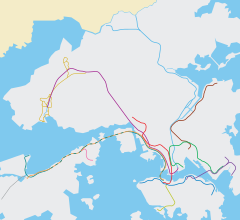
 Kwun Tong Location within the MTR system | ||||||||||||||||||||||||||||||||||||||||||||||||||||||||||||||||||||||||||||||||||||||||||||||||||
The station is elevated and open-air, unlike almost every other station on the line. Only Ngau Tau Kok and Kowloon Bay stations are like this. Due to difficulties in installing platform screen doors (PSDs) in above ground stations, the MTR decided not to install PSDs in this station, instead installing automatic platform gates (APGs) on the station's platforms in 2011.
It is located far away from most residential areas, causing many residents of Kwun Tong to take other means of transport in order to reach the station. There is a shopping centre and office tower, named apm Millennium City 5, connected to the station.
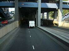
Beneath the station building is a road tunnel which diverts traffic along Kwun Tong Road from the roundabout around the station.
History
Kwun Tong station was opened when Modified Initial System was opened on 1 October 1979, and act as the terminus of the system, until Kwun Tong Line was extended to Quarry Bay in 1989.
Station layout

Platforms 1 and 2 share the same island platform, and it is curved, so the gap is large. Before Lam Tin station was opened, platform 1 was also used for departing westbound trains. After midnight, platform 1 is the termination platform of the Kwun Tong Line, so trains can return to Kowloon Bay Depot.
| P Platforms |
Platform 1 | Kwun Tong line towards Tiu Keng Leng (Lam Tin) → |
| Island platform, doors will open on the right | ||
| Platform 2 | ← Kwun Tong line towards Whampoa (Ngau Tau Kok) | |
| C | Concourse | Customer service, MTRshops |
| Hang Seng Bank, vending machines, automatic teller machines | ||
| Octopus promotion machine | ||
| G | Ground level | Exits |
| - |
- | Kwun Tong Road Tunnel |
Entrances/exits
- A1: Yue Man Square

- A2: Millennium City 5, APM Mall

- B1: Kwun Tong Ferry Pier Harbourfront
- B2: Kwun Tong Plaza
- B3: Crocodile Center
- C1: Yuet Wah Street
- C2: Lei Yue Mun Road
- C3: Hip Wo Street
- D1: Bus Terminus
- D2: Hip Wo Street

- D3: Hoi Yuen Road
- D4: Kwun Tong Industrial Centre[2]
Transport connections
Public light bus routes
To Sau Mau Ping/Po Tat Estate:
- 13 (Exit A1)
To Cha Kwo Leng:
- 23B (Exit A1)
To United Christian Hospital:
- 47 (Exit D1)
- 50 (Exit A1)
To Hiu Lai Court/Upper Sau Mau Ping:
- 34M (Exit A1)
To Hong Lee Court(Crocodile Hill):
- 36A (Exit A1)
To Lok Wah Estate and Chun Wah Road:
- 22M (Exit A1)
To Tsui Ping Estate:
- 59 (Exit D1)
- 59M (Exit C3)
Bus routes
To Hing Tin Estate / Kai Tin Estate:
- 16M (Exit D1)
To Po Tat Estate / Sau Mau Ping Estate:
- 13M (Exit D1)
To Lek Yuen Estate / New Town Plaza (Sha Tin)
- 89
To Sha Kok Estate / Pok Hong Estate / Sha Tin Wai / Tai Wai
- 89B
To Sha Tin Station / City One
- 89X
References
- "Kwun Tong Station layout" (PDF). MTR Corporation. Retrieved 25 July 2014.
- "Kwun Tong Station street map" (PDF). MTR Corporation. Retrieved 25 July 2014.