Kushmandi, Dakshin Dinajpur
Kushmandi (also referred to as Kushmundi) is a village in Kushmandi CD Block in Gangarampur subdivision of Dakshin Dinajpur district in the state of West Bengal, India.
Kushmandi | |
|---|---|
Village | |
 Kushmandi Location in West Bengal, India  Kushmandi Kushmandi (India) | |
| Coordinates: 25.53036°N 88.365269°E | |
| Country | |
| State | West Bengal |
| District | Dakshin Dinajpur |
| Population (2011) | |
| • Total | 3,948 |
| Languages | |
| • Official | Bengali, English |
| Time zone | UTC+5:30 (IST) |
| PIN | 733132 |
| STD/ Telephone code | 03524 |
| Lok Sabha constituency | Balurghat |
| Vidhan Sabha constituency | Kushmandi |
| Website | ddinajpur |
Geography
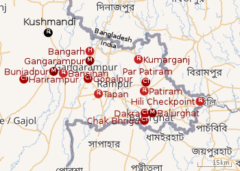 |
| Cities and towns in the Dakshin Dinajpur district M: municipal city/ town, CT: census town, R: rural/ urban centre, H: historical site Owing to space constraints in the small map, the actual locations in a larger map may vary slightly |
Location
Kushmandi is located at 25.53036°N 88.365269°E
In the map alongside, all places marked on the map are linked in the full screen version.
Demographics
As per the 2011 Census of India, Kushmundi had a total population of 3,948, of which 1,999 (51%) were males and 1,949 (49%) were females. Population below 6 years was 371. The total number of literates in Kushmundi was 3,104 (86.78% of the population over 6 years).[5]
Transport
State Highway 10A passes through Kushmandi.[6]
New broad gauge line from Kaliaganj to Buniadpur (33.10 km), passing through Kushmandi, was included in the budget 2010-11. 157.938 ha of land to be acquired. As of August 2018, project work by Northeast Frontier Railway held up mainly because of paucity of funds.[7]
Education
Kushmandi Government College was established at Kushmandi in 2015. It is affiliated to Gour Banga University and offers honours courses in Bengali, English, history, philosophy and political science, and general courses in arts and science.[8][9]
Healthcare
Kushmandi Rural Hospital at Kushmandi (with 30 beds) is the main medical facility in Kushmandi CD Block. There are primary health centres at Sehail (Nanaharpara PHC) (with10 beds) and Aminpur (with 10 beds).[10]
References
- "District Statistical Handbook 2014 Dakshin Dinajpur". Table 2.1. Department of Statistics and Programme Implementation, Government of West Bengal. Retrieved 4 December 2018.
- "Dakshin Dinajpur District Police". Know your PS. District Police. Archived from the original on 28 November 2017. Retrieved 4 December 2018.
- "District Census Handbook: Dakshin Dinajpur, Series 20 Part XII A" (PDF). Map of Dakshin Dinajpur with CD Block HQs and Police Stations (on the fourth page). Directorate of Census Operations, West Bengal, 2011. Retrieved 4 December 2018.
- "BDO Offices under Dakshin Dinajpur District". Department of Mass Education Extension & Library Services, Government of West Bengal. West Bengal Public Library Network. Retrieved 4 December 2018.
- "2011 Census – Primary Census Abstract Data Tables". West Bengal – District-wise. Registrar General and Census Commissioner, India. Retrieved 11 November 2018.
- Google maps
- "Brief of all projects (as of 31st August 2018)" (PDF). Page 15: New BG line from Kaliaganj to Buniadpur (33.10 Km). Northeast Frontier Railway (Cconstruction). Archived from the original (PDF) on 2 December 2018. Retrieved 2 December 2018.
- "Government General Degree College, Kushmandi". GGDC. Retrieved 4 December 2018.
- "Kushmandi Government College". examfinder. Retrieved 4 December 2018.
- "Health & Family Welfare Department". Health Statistics. Government of West Bengal. Retrieved 7 December 2018.
Cities, towns and locations in Dakshin Dinajpur district | |||||
|---|---|---|---|---|---|
| Cities, municipal and census towns |
| ||||
| Locations other than cities and towns |
| ||||
| Related topics |
| ||||