Kumlu
Kumlu is a district of Hatay Province, in the Amik Valley plain, on the road between Antakya and Reyhanlı in Turkey.
- For the village in Azerbaijan, see Qumlu.
Kumlu | |
|---|---|
 Kumlu | |
| Coordinates: 36°22′22″N 36°27′10″E | |
| Area | |
| • District | 223.09 km2 (86.14 sq mi) |
| Elevation | 89 m (292 ft) |
| Population (2012)[2] | |
| • Urban | 4,855 |
| • District | 13,065 |
| • District density | 59/km2 (150/sq mi) |
| postal code | 31520 |
| Website | www.kumlu.bel.tr |
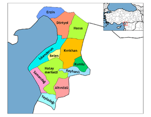
The districts of Hatay
History
Kumlu is known for the mineral baths of "Hamamat". Kumlu was founded in 1968 by Aziz Tavım.
Geography
The Area of Kumlu is 193 km2.[3] At north of Kumlu there is Kırıkhan, at northwest Belen, at east Syria, at south Reyhanlı and at west Antakya. General land of Kumlu is very flat. Amik Plain includes tiny plateaus. Height of Kumlu is 97 meter(318 feet). Centre of Kumlu is at a flat area in Amik Plain.[4]
Population
| Year | Total | Urban | District |
|---|---|---|---|
| 1990[5] | 15.541 | 6.142 | 9.399 |
| 2000[6] | 16.070 | 6.629 | 9.441 |
| 2007[7] | 13.210 | 5.452 | 7.758 |
| 2008[8] | 13.726 | 5.255 | 8.471 |
| 2009[9] | 13.623 | 5.167 | 8.456 |
| 2010[10] | 13.239 | 4.923 | 8.316 |
| 2011[11] | 13.156 | 4.879 | 8.277 |
| 2012[12] | 13.065 | 4.855 | 8.210 |
| 2013[13] | 13.241 | 13.241 | |
| 2014[14] | 13.345 | 13.345 |
gollark: Imagine not running Discord inside Firefox/
gollark: This is a very good* use of a filesystem.
gollark: Imagine efficiently utilizing time.
gollark: No, you don't have breaks because breaks mean less macron.
gollark: <@!341618941317349376> make macron.
References
- "Area of regions (including lakes), km²". Regional Statistics Database. Turkish Statistical Institute. 2002. Retrieved 2013-03-05.
- "Population of province/district centers and towns/villages by districts - 2012". Address Based Population Registration System (ABPRS) Database. Turkish Statistical Institute. Retrieved 2013-02-27.
- "Kumlu Republic Area Statistics" (PDF). General Commanding of Maps.
- "Kumlu Republic Geographical Data". Kumlu Directorate of Meteorology.
- "1990 general population count data". Turkish Statistical Institute. Archived from the original on 2012-11-03.
- "2000 general population count data". Turkish Statistical Institute. Archived from the original on 2012-11-03.
- "2007 general population count data". Turkish Statistical Institute. Archived from the original on 2012-11-03.
- "2008 general population count data". Turkish Statistical Institute. Archived from the original on 2012-11-03.
- "2009 general population count data". Turkish Statistical Institute. Archived from the original on 2012-11-03.
- "2010 general population count data". Turkish Statistical Institute. Archived from the original on 2012-11-03.
- "2011 general population count data". Turkish Statistical Institiute. Archived from the original on 2012-11-03.
- "2012 general population count data". Turkish Statistical Institute. Archived from the original on 2013-02-20.
- "2013 general population count data". Turkish Statistical Institute. Archived from the original on 2014-02-15.
- "2014 general population count data". Turkish Statistical Institute. Archived from the original on February 10, 2015.
Kumlu in Hatay Province of Turkey | |||||||||||||||||||||||||||
|---|---|---|---|---|---|---|---|---|---|---|---|---|---|---|---|---|---|---|---|---|---|---|---|---|---|---|---|
| Districts | Districts of Hatay | ||||||||||||||||||||||||||
| |||||||||||||||||||||||||||
Metropolitan municipalities are bolded. | |||||||||||||||||||||||||||
This article is issued from Wikipedia. The text is licensed under Creative Commons - Attribution - Sharealike. Additional terms may apply for the media files.