Kokpara
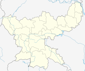
Kokpara is a town in East Singhbhum district, Jharkhand, India.
Kokpara | |
|---|---|
village | |
 Kokpara Location in Jharkhand, India  Kokpara Kokpara (India) | |
| Coordinates: 22°28′0″N 86°36′0″E | |
| Country | |
| State | Jharkhand |
| District | East Singhbhum |
| Elevation | 92 m (302 ft) |
| Languages | |
| • Official | Hindi, Santali |
| Time zone | UTC+5:30 (IST) |
| Vehicle registration | JH |
| Coastline | 0 kilometres (0 mi) |
Geography
It is located at 22°28′0″N 86°36′0″E at an elevation of 92 m from MSL.[1]
Location
National Highway 33 passes through Kokpara. Nearest airport is Ranchi Airport and nearest railway station is at Tatanagar. Jamshedpur is 80 km from Kokpara.
gollark: ddg! void star
gollark: You should clearly™ designate a channel for AutoBotRobot Apiotelephone™ incoming/outgoing calls.
gollark: DST bad:- vast work for programmers, has caused many bugs- not even consistent times place to place, so even more problems- causes problems for less smart clocks without access to timezone databases e.g. watches, wall clocks- essentially the most "government" thing ever - someone identified a "problem" with stuff happening at the wrong times, so the solution was to *edit the very fabric of time itself* and not push for changed working hours
gollark: Hmm, we need generalized timezones, lyricly, then. What if I want to be on Mars?
gollark: It's very hot constantly and they don't think the alleged benefits matter?
References
- http://www.fallingrain.com/world/IN/38/Kokpara.html Map and weather of Kokpara
This article is issued from Wikipedia. The text is licensed under Creative Commons - Attribution - Sharealike. Additional terms may apply for the media files.