Kidmore End
Kidmore End is a village and civil parish in South Oxfordshire, centred 6 miles (10 km) NNW of Reading, Berkshire, an important regional centre of commerce, research and engineering. It is in the low Chiltern Hills, partly in the Area of Outstanding Natural Beauty. The A4074 from Reading towards Oxford passes through the west of the parish and it is located 6 miles from Henley on Thames.
| Kidmore End | |
|---|---|
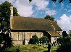 St John the Baptist parish church | |
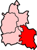
 Kidmore End Location within Oxfordshire | |
| Area | 10.90 km2 (4.21 sq mi) |
| Population | 1,302 (parish, including Gallowstree Common) (2011 census)[1] |
| • Density | 119/km2 (310/sq mi) |
| OS grid reference | SU6979 |
| Civil parish |
|
| District | |
| Shire county | |
| Region | |
| Country | England |
| Sovereign state | United Kingdom |
| Post town | Reading |
| Postcode district | RG4 |
| Dialling code | 0118 |
| Police | Thames Valley |
| Fire | Oxfordshire |
| Ambulance | South Central |
| UK Parliament | |
| Website | Kidmore End Parish Council |
Amenities and geography
The village is dispersed into four built-up streets or small clusters of homes and has half-timbered cottages, housing ranging from early Georgian to a few late 20th century and early 21st century homes [2] and a public house, the New Inn.[3]
The Church of England parish church of Saint John the Baptist, designed by Arthur Billing, was built in 1852.[4] The village school was opened in 1856 and is now a Church of England primary school.[5]
Kidmore End Cricket Club plays in the Thames Valley Cricket League.[6]
The nearest shop, café and small business services are in Sonning Common, centred 0.5 miles (1 km) north-east. The area is about 3 miles (5 km) long at its longest (north-west to south-east) and includes the named localities of Gallowstree Common by a wooded common, Cane End, Chalkhouse Green and Tokers Green.
Land use
The land use statistics published with the 2011 census show that the area was mostly greenspace, which is agriculture and woodland in this area, with the next highest land use category being domestic gardens, followed by roads, non-domestic buildings and domestic buildings.[7]
Nearest places
Nearest places (by civil parish) | ||||||||||
|---|---|---|---|---|---|---|---|---|---|---|
| ||||||||||
References
- "Area: Kidmore End CP (Parish): Parish Headcounts". Neighbourhood Statistics. Office for National Statistics. Retrieved 17 March 2010.
- Sherwood & Pevsner 1974, p. 673.
- The New Inn
- Sherwood & Pevsner 1974, p. 672.
- Kidmore End School
- Kidmore End Cricket Club Archived 15 July 2011 at the Wayback Machine
- Key Statistics: Dwellings; Quick Statistics: Population Density; Physical Environment: Land Use Survey 2005
Sources
- Sherwood, Jennifer; Pevsner, Nikolaus (1974). Oxfordshire. The Buildings of England. Harmondsworth: Penguin Books. pp. 672–673. ISBN 0-14-071045-0.CS1 maint: ref=harv (link)
External links
| Wikimedia Commons has media related to Kidmore End. |