Khotang District
Khotang District (Nepali: खोटाङ जिल्ला![]()
Khotang District खोटाङ जिल्ला | |
|---|---|
District | |
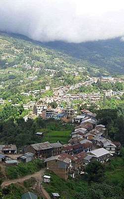 A view of Diktel Bazar, Khotang | |
 | |
| Coordinates: 27°12′N 86°47′E | |
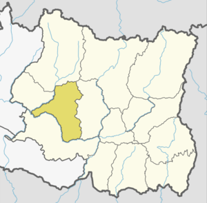
| Country | |
| Province | Province No. 1 |
| Established | 1962 |
| Admin HQ. | Diktel |
| Government | |
| • Type | Coordination committee |
| • Body | DCC, Khotang |
| • Head | Mr. Kamal Bhim Raj Khadka |
| • Deputy-Head | Mrs. Indra Kala Khadka |
| • Parliamentary constituencies | 1 |
| • Provincial constituencies | 2 |
| Area | |
| • Total | 1,591 km2 (614 sq mi) |
| Population (2011 [1]) | |
| • Total | 206,312 |
| • Density | 130/km2 (340/sq mi) |
| Time zone | UTC+05:45 (NPT) |
| Website | ddckhotang |
History
Before the unification of Nepal, Khotang District was a part of Majha Kirat or Khambuwan. The land area between two rivers from Dudh Koshi to Arun was Majha Kirat and it was under suzerainty of Sen King of Chaudandigadhi.[3]
During Rana rule, Nepal had 32 districts and the current Khotang District was divided into two previous districts. Half of the north part of the current Khotang district was part of East No. 3 (Okhaldhunga) and half of southern part of current Khotang was part of East No. 4 (Bhojpur).[4] In 1962 the traditional 32 districts were divided into 75 districts[5] thus Khotang county of East No. 4 and some counties from "East No. 3" merged and made the current Khotang District.
Geography and climate
Geographically, Khotang is a hilly district of Eastern Nepal. It lies on the coordinates of 260° 50" N to 270° 28" N latitude and 860° 26" E to 860° 58" E longitude. Coordinates of the center is 27° 11' 60.00" N and 86° 46' 59.99" E. Total area of the district is 1,591 square kilometres (614 sq mi).[6] The elevations of the district is 152 m to 3620 m from the sea level.[7] Sunkoshi River and Dudh Koshi river makes natural borders in the North, West and South and a series of hills and small river makes border separating it from Bhojpur District in East. Approximately 56% of the district area is covered with forest. And about 42% of the district area is under cultivation.[2]
| Climate Zone[8] | Elevation Range | % of Area |
|---|---|---|
| Lower Tropical | below 300 meters (1,000 ft) | 0.7% |
| Upper Tropical | 300 to 1,000 meters 1,000 to 3,300 ft. |
31.5% |
| Subtropical | 1,000 to 2,000 meters 3,300 to 6,600 ft. |
49.1% |
| Temperate | 2,000 to 3,000 meters 6,400 to 9,800 ft. |
16.3% |
| Subalpine | 3,000 to 4,000 meters 9,800 to 13,100 ft. |
1.6% |
Demographics
At the time of the 2011 Nepal census, Khotang District had a population of 206,312. Of these, 50.1% spoke Nepali, 16.5% Chamling, 4.4% Magar, 3.9% Tamang, 3.7% Bantawa, 3.5% Sampang, 2.7% Newari, 2.5% Dumi, 2.2% Puma, 1.9% Thulung, 1.5% Wambule, 1.3% Nachhiring, 0.9% Koch, 0.8% Rai, 0.6% Sherpa, 0.5% Tilung and 0.5% Khaling as their first language.
43.0% of the population in the district spoke Nepali, 1.1% Bantawa and 0.6% Chamling as their second language.[9]
Administration
Khotang District is administered by Khotang District Coordination Committee (Khotang DCC). The Khotang DCC is elected by Khotang District Assembly. The head of Khotang DCC is Mr. Kamal Bhimraj Khadka and Mrs. Indrakala Khadka is deputy head of Khotang DCC.
Khotang District Administration Office under Ministry of Home Affairs co-operate with Khotang DCC to maintain peace, order and security in the district. The officer of District Administration office called CDO and current CDO of Khotang DAO is Bishnuhari Upadhyay
Khotang District Court is a Judicial court to see the cases of people on district level.
| Administration | Name | Head | Website |
|---|---|---|---|
| Legislative | District Coordination Committee | Mr. Bobby Chamling | dcckhotang |
| Executive | District Administration Office | Mr. Shaligram Sharma Paudel | daokhotang |
| Judicial | District Court | Mr. Matrika Prasad Acharya | supremecourt |
Division
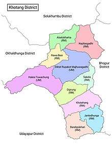
RM=Rural municipality
UM=Urban municipality
The district consists of 10 Municipalities, out of which two are urban municipalities and eight are rural municipalities. These are as follows:[10]
| # | Local body | Nepali | Population (2011) | Area (KM2) | Mayor | Deputy Mayor | Wards | Web |
|---|---|---|---|---|---|---|---|---|
| 1 | Diktel Rupakot Majhuwagadhi | रूपाकोट मझुवागढी | 46903 | 246.51 | 15 | |||
| 2 | Halesi Tuwachung | हलेसी तुवाचुङ | 29532 | 280.17 | 11 | |||
| 3 | Khotehang | खोटेहाङ | 22474 | 164.09 | 9 | |||
| 4 | Diprung | दिप्रुङ | 20175 | 136.48 | 7 | |||
| 5 | Aiselukharka | ऐंसेलुखर्क | 16097 | 125.93 | 7 | |||
| 6 | Jantedhunga | जन्तेढुँगा | 15444 | 128.62 | 6 | |||
| 7 | Kepilasgadhi | केपिलासगढी | 15288 | 191.28 | 7 | |||
| 8 | Barahpokhari | बराहपोखरी | 14349 | 141.6 | 6 | |||
| 9 | Rawabesi | रावाबेसी | 13369 | 97.44 | 6 | |||
| 10 | Sakela | साकेला | 11594 | 97.99 | 5 |
Former divisions (1962-2015)
Prior to the restructuring of the district, Khotang District consisted of the following municipalities and Village development committees:
[11]
(Before 2014, Khotang district had 76 VDC and no municipality. Diktel municipality established in 2014 merging some VDC)
Places of Interest
- Halesi-Maratika Caves - A pilgrimage site for Hindus located in Halesi Tuwachung municipality.
- Barah Pokhari is a lake and a religious destination, as well as a part of trekking trail located in Barahapokhari rural municipality.
- Hill, mountains, rivers trekking and more
References
- Household and population by districts, Central Bureau of Statistics (CBS) Nepal Archived 2013-09-27 at the Wayback Machine
- "Brief Introduction of Khotang District". Retrieved 20 January 2020.
- "खोटाङ जिल्लाको इतिहास" [History of Khotang District] (in Nepali). 8 December 2013. Retrieved 20 January 2020.
- "Brief introduction of Okhaldhunga". DCC Okhaldhunga. Retrieved 30 March 2020.
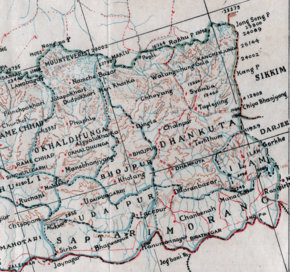
Okhaldhunga along with Khotang and Solukhumbu were combined to form East No.3 area among the 32 districts of administrative division of Prime Minister Bhimsen Thapa recently after the unification campaign of His Majesty the King Prithvi Narayan Shah. At that time the headquarter of East No.3 area was Okhaldhunga as of today.
- "A Guide to Government in Nepal" (PDF). Retrieved 30 March 2020.
In 1961, the country was demarcated into 14 administrative zones with each zone headed by a zone commissioner, a royal appointee whose function, among others, was to assist the palace secretariat in suppressing political opposition. In the districts, now increased in number to 75 from 35, district panchayats were established by amalgamating the former village development blocks, and village and nagar (town) panchayats were also established.
- "Latitude and longitude of Khotang District". Retrieved 21 January 2020.
- "संक्षिप्त परिचय" [Short Introduction] (in Nepali). Retrieved 21 January 2020.
- The Map of Potential Vegetation of Nepal - a forestry/agroecological/biodiversity classification system (PDF), . Forest & Landscape Development and Environment Series 2-2005 and CFC-TIS Document Series No.110., 2005, ISBN 87-7903-210-9, retrieved November 22, 2013
- 2011 Nepal Census, Social Characteristics Tables
- "स्थानिय तह" (in Nepali). Ministry of Federal Affairs and General Administration. Archived from the original on 31 August 2018. Retrieved 1 September 2018.
- "National Population and Housing Census 2011" (PDF). 2011. Archived from the original (PDF) on 28 December 2013. Retrieved 2 November 2014.
- "Districts of Nepal". Statoids.
| Wikimedia Commons has media related to Khotang District. |
Places adjacent to Khotang District | |
|---|---|
Headquarter: Diktel | ||
| Urban Municipality | | |
| Rural Municipality |
| |
For former VDCs See here | ||