Parsa District
Parsa District (Nepali: पर्सा जिल्ला![]()
Parsa Rangrez District पर्सा रंगरेज जिल्ला | |
|---|---|
District | |
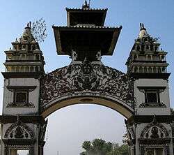 The gate in Birganj on the Indo-Nepal border | |
 | |
| Country | |
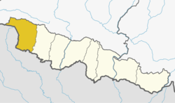
| Province | Province No. 2 |
| Admin HQ. | Birganj |
| Government | |
| • Type | Coordination committee |
| • Body | DCC, Parsa |
| • King | King Aman Chouhan |
| Area | |
| • Total | 1,353 km2 (522 sq mi) |
| Population (2011) | |
| • Total | 601,017 |
| • Density | 440/km2 (1,200/sq mi) |
| Time zone | UTC+05:45 (NPT) |
| Main Language(s) | Bhojpuri (78.1%), Nepali (6.4%), Maithili (5.1%), Tharu (3.8%), Urdu (2.2%), others (4.4%) |
Geography and Climate
| Climate Zone[1] | Elevation Range | % of Area |
|---|---|---|
| Lower Tropical | below 300 meters (1,000 ft) | 74.7% |
| Upper Tropical | 300 to 1,000 meters 1,000 to 3,300 ft. |
25.3n% |
Demographics
At the time of the 2011 Nepal census, Parsa District had a population of 601,017. Of these, 78.1% spoke Bhojpuri, 6.4% Nepali, 5.1% Maithili, 3.8% Tharu, 2.2% Urdu, 1.3% Tamang, 0.8% Rajasthani and 0.7% Newari as their first language.
30.4% of the population in the district spoke Nepali, 5.4% Bhojpuri and 4.9% Hindi as their second language.[2]
Administration
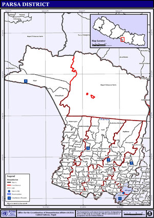
VDC/s and Municipalities (blue) in Parsa District The district consists of one metropolitan city, three urban municipalities and ten rural municipalities. These are as follows:
- Birgunj Metropolitan
- Bahudarmai Municipality
- Parsagadhi Municipality
- Pokhariya Municipality
- Bindabasini Rural Municipality
- Dhobini Rural Municipality
- Chhipaharmai Rural Municipality
- Jagarnathpur Rural Municipality
- Jirabhawani Rural Municipality
- Kalikamai Rural Municipality
- Pakaha Mainpur Rural Municipality
- Paterwa Sugauli Rural Municipality
- Sakhuwa Prasauni Rural Municipality
- Thori Rural Municipality
Former Village Development Committees (VDCs) and municipalities
- Alau,
- Amarpatti
- Auraha
- Bagahi
- Bagbana
- Bageshwari
- Bahauri Pidari
- Bahuarwa bhatha
- Basadilwa
- Basantpur
- Belwa Parsauni
- Beriya Birta
- Bhauratar
- Bhawanipur
- Bhedihari
- Bhisawa
- Bijbaniya
- Bindyabasini
- Biranchi Barwa
- Birganj Municipality
- Biruwa Guthi
- Bisrampur
- Chorani
- Deurbaana
- Dhobini
- Gadi
- Gamhariya
- Ghoddauda Pipra
- Ghore
- Govindapur
- Hariharpur
- Hariharpur Birta
- Harapatganj
- Harpur
- Jagarnathpur Sira
- Jaimanglapur
- Janikatala
- Jhauwa Guthi
- Jitpur
- Kauwa Ban Kataiya
- Lahawarthakari
- Lakhanpur
- Lal Parsa
- Langadi
- Lipani Birta
- Madhuban Mathaul
- Mahadevpatti
- Mahuwan
- Mainiyari
- Mainpur
- Mikhampur
- Mirjapur
- Mosihani
- Mudali
- Nagardaha
- Nirchuta
- Nirmal Basti
- Pancharukhi
- Parsauni Birta
- Parsauni Matha
- Patbari Tola-Warwa
- Paterwa Sugauli
- Pidariguthi
- Pokhariya Municipality
- Phulwariya
- Prasurampur
- Ramgadhawa
- Ramnagari
- Sabaithawa
- Sakhuwa Prasauni
- Samjhauta
- Sankar Saraiya
- Sapauli
- Sedhawa
- Shiva Worga
- Sirsiya Khalwatola
- Sonbarsa
- Srisiya
- Subarnapur
- Sugauli Birta
- Sugauli Partewa
- Surjaha
- Thori
- Tulsi Barba
- Udaypur Dhursi
References
- The Map of Potential Vegetation of Nepal - a forestry/agroecological/biodiversity classification system (PDF), Forest & Landscape Development and Environment Series 2-2005 and CFC-TIS Document Series No.110., 2005, ISBN 978-87-7903-210-1, retrieved Nov 22, 2013
- 2011 Nepal Census, Social Characteristics Tables
- "Districts of Nepal". Statoids.
| Wikimedia Commons has media related to Parsa District. |
Places adjacent to Parsa District | |
|---|---|
Headquarter: Birgunj | ||
| Metropolitan City | | |
| Municipalities | ||
| Rural municipalities | ||