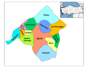
Keçiborlu
Keçiborlu is a town and district of Isparta Province in the Mediterranean region of Turkey. The town had 7,049 inhabitants according to 2010 census.
Keçiborlu | |
|---|---|
 Keçiborlu | |
| Coordinates: 37°56′35″N 30°18′08″E | |
| Country | |
| Province | Isparta |
| District | Keçiborlu |
| Government | |
| • Mayor | Turgut Soykan |
| Area | |
| • District | 535.75 km2 (206.85 sq mi) |
| Elevation | 1,010 m (3,310 ft) |
| Population (2012)[2] | |
| • Urban | 6,924 |
| • District | 14,819 |
| • District density | 28/km2 (72/sq mi) |
| Post code | 32700 |
| Website | www.keciborlu.bel.tr |
Etymology
The town was known as Eudoxipolis (Ευδοξίπολη in Greek) during the Roman and early Byzantine periods. By the 12th century it was known as Sublaeum.[3]
History
Keçiborlu is known as the site where Atlasjet Flight 4203 crashed on November 30, 2007.
Economy
In the early 20th-century, sulphur was mined in the area.[4]
gollark: 2π swallow-radians.
gollark: Not the apiorectionic thing.
gollark: The shipping.
gollark: Done.
gollark: I'll ship you some.
References
- "Area of regions (including lakes), km²". Regional Statistics Database. Turkish Statistical Institute. 2002. Retrieved 2013-03-05.
- "Population of province/district centers and towns/villages by districts - 2012". Address Based Population Registration System (ABPRS) Database. Turkish Statistical Institute. Retrieved 2013-02-27.
- Cahen, C. (2000) The Formation of Turkey: The Seljukid Sultanate of Rum: Eleventh to Fourteenth Century, Routledge, pp. 30-31
- Prothero, G.W. (1920). Anatolia. London: H.M. Stationery Office. p. 107.
This article is issued from Wikipedia. The text is licensed under Creative Commons - Attribution - Sharealike. Additional terms may apply for the media files.
