Karasu
Karasu is a town in Sakarya Province, northwestern Turkey, on the Black Sea coast. It has an overwinter population of around 30,746, which increases in the summer due to tourism. Much of its commerce centers on hazelnut farming and tourism.
Karasu | |
|---|---|
 Karasu | |
| Coordinates: 41°6′13″N 30°41′37″E | |
| Country | |
| Province | Sakarya |
| Government | |
| • Mayor | İshak Sarı (AKP) |
| • Kaymakam | Murat Duru |
| Area | |
| • District | 481.69 km2 (185.98 sq mi) |
| Population (2012)[2] | |
| • Urban | 30,746 |
| • District | 54,434 |
| • District density | 110/km2 (290/sq mi) |
| Post code | 54500 |
| Climate | Cfb |
| Website | www.sakaryakarasu.bel.tr |

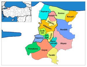
Karasu district in Sakarya Province.
The Acarlar Floodplain Forest is located partly in Karasu.[3]
Economy
Historically, Karasu has produced zinc and lead, which they started mining in 1898. When World War I started, production in the area declined.[4]
gollark: They cooperate constantly, so sounds right.
gollark: Did you change stuff?
gollark: ```(iter-prisond tit-for-tat devil 10)(0 30)```
gollark: ```(iter-prisond devil grudger 10)(30 0)```<:dodecahedron:724893894822854697>
gollark: This is immensely troubling.
References
- "Area of regions (including lakes), km²". Regional Statistics Database. Turkish Statistical Institute. 2002. Retrieved 2013-03-05.
- "Population of province/district centers and towns/villages by districts - 2012". Address Based Population Registration System (ABPRS) Database. Turkish Statistical Institute. Retrieved 2013-02-27.
- "Acarlar Gölü Longozu" (in Turkish). Sakarya Orman ve Su İşleri Müdürlüğü. Retrieved 2016-10-29.
- Prothero, G.W. (1920). Anatolia. London: H.M. Stationery Office. p. 103.
| Wikimedia Commons has media related to Karasu, Sakarya. |
This article is issued from Wikipedia. The text is licensed under Creative Commons - Attribution - Sharealike. Additional terms may apply for the media files.